
Doughoregan Manor facts for kids
|
Doughoregan Manor
|
|

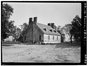
Doughoregan Manor, 1936
|
|

Location in Maryland

Location in the United States
|
|
| Location | Manor Lane, Ellicott City, Maryland |
|---|---|
| Area | 900 acres (360 ha) (landmarked area) |
| Built | est. 1727 |
| Architectural style | Greek Revival |
| NRHP reference No. | 71000376 |
Quick facts for kids Significant dates |
|
| Added to NRHP | November 11, 1971 |
| Designated NHL | November 11, 1971 |
Doughoregan Manor (pronounced doe-RAY-gen) is a large, historic estate and house in Ellicott City, Maryland. It was built in the early 1700s and became the home of the important Carroll family in Maryland. One famous resident was Charles Carroll of Carrollton, who signed the United States Declaration of Independence.
Today, Doughoregan Manor is still owned by the Carroll family. It is a National Historic Landmark, which means it's a very important historical place. The estate is private and not open to the public.
Contents
History of Doughoregan Manor
Doughoregan Manor began as a large estate in the early 1700s. It was founded by Charles Carroll the Settler in 1702. He named it "Doughoreagan" after a family estate in Ireland. The estate grew to 10,000 acres by 1717.
The main house was built around 1727 by Charles Carroll of Annapolis. It was designed in the Georgian style, which was popular at the time. Later, in 1832, the house was made bigger and updated. This was done by Charles Carroll V, who added features in the Greek Revival style.
Home of a Founding Father
From 1766 to 1832, Doughoregan Manor was the country home of Charles Carroll of Carrollton. He was also known as Charles Carroll III. He was the last person to sign the United States Declaration of Independence who was still alive. He is buried in a special chapel connected to the house.
Many important people visited the manor over the years. These guests included George Washington, Thomas Jefferson, John Adams, and Benjamin Franklin. Even Marquis de Lafayette, a French hero of the American Revolution, visited. Later, in 1861, John Lee Carroll lived here. He became the Governor of Maryland.
The Manor's Design
The manor house is a large brick building with two stories. It is shaped like a "U." The roof has different sections, some with decorative railings. In the middle of the roof, there is a small, eight-sided tower called a cupola. The front entrance has a porch with four columns. A similar porch is at the back of the house.
A private chapel is attached to the manor house. This chapel was very important because, for a long time, it was hard to build Roman Catholic churches in the colony. The chapel served as the main meeting place for local Catholics until the mid-1800s. It was even open to the public for Sunday Mass until the 1990s.
Life at the Manor
In 1770, a vineyard was planted at Doughoregan Manor. It grew four types of grapes and was one of the oldest vineyards in the colonies. The Carroll family also loved breeding and racing horses. They would compete with other wealthy families in annual racing events. These events were important social gatherings.
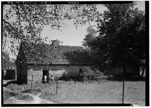
During the American Civil War, the manor was used to store supplies for Southern supporters. By 1931, the estate was still very large. It included the main house, barns, tenant houses, and other farm buildings.
Today, members of the Carroll family still live in the manor. The estate is much smaller than it used to be. Over the years, parts of the land have been divided among family members or sold for new developments. However, a large part of the original land is still owned by the family. The manor and its private road are not open to visitors.
Preserving the Estate
In 1971, Doughoregan Manor was named a National Historic Landmark. At first, only about 900 acres of the estate were included in this special status. The owner, Phillip Carroll, wanted to keep some land for future building.
However, a few years later, a new law offered tax benefits for preserving historic properties. So, the owner decided to include all the land in the landmark status. This helped protect the large estate.
Future Plans and Challenges
Around 2007, the special tax benefits for the estate ended. The Carroll family wanted to keep the property mostly undeveloped. In 2008, they tried to sell 150 acres to a company that builds retirement communities, but the deal didn't happen. The family mentioned that it was hard to find money to fix up the old buildings.
In 2010, the local government agreed to pay the Carroll family to keep 500 acres of the land as farmland. This helps protect the open space. Also, some land was set aside for new homes to be built. This plan caused some concern among neighbors.
In 2015, the manor received tax credits to help with repairs. These credits are given to help preserve important historic buildings.
Description of the House
The house was originally a smaller brick building with 1.5 stories. It had a special roof shape called a gambrel roof. A separate brick chapel was to the north, and a kitchen was to the south.
In the 1830s, these separate buildings were connected to the main house. The main house was also made taller, becoming a two-story building. A decorative deck and an eight-sided cupola were added to the new roof. The front of the house gained a porch with columns. The chapel and kitchen were joined to the main house by two-story hallways. This made the house very long, almost 300 feet!
Inside, the house has a long main hallway that goes from the front to the back. There are stairs in a smaller hallway on the north side. The first floor has a library, a large living room, a smaller living room, and a dining room. The bedrooms are on the second floor.
