Downieville-Lawson-Dumont, Colorado facts for kids
Quick facts for kids
Downieville-Lawson-Dumont, Colorado
|
|
|---|---|

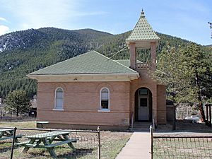
The Dumont School in Dumont.
|
|

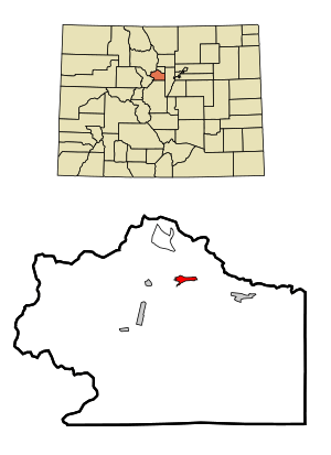
Location of the Downieville-Lawson-Dumont CDP in Clear Creek County, Colorado.
|
|
| Country | |
| State | |
| County | Clear Creek County |
| Government | |
| • Type | unincorporated communities |
| Area | |
| • Total | 2.068 km2 (0.798 sq mi) |
| • Land | 2.014 km2 (0.778 sq mi) |
| • Water | 0.054 km2 (0.021 sq mi) |
| Elevation | 2,441 m (8,009 ft) |
| Population
(2020)
|
|
| • Total | 527 |
| • Density | 254.84/km2 (660.0/sq mi) |
| Time zone | UTC-7 (MST) |
| • Summer (DST) | UTC-6 (MDT) |
| ZIP Code |
Dumont 80436
|
| Area codes | 303 & 720 |
| GNIS feature ID | 2408685 |
Downieville-Lawson-Dumont is a special kind of community in Colorado, United States. It's not a city or town, but a "census-designated place" (CDP). This means it's an area defined by the government for counting people. It includes three smaller communities: Downieville, Lawson, and Dumont. These places are all located in Clear Creek County, Colorado. The area is also part of the larger Denver metropolitan area. In 2020, about 527 people lived here.
Contents
What is Downieville-Lawson-Dumont?
Downieville-Lawson-Dumont is a "census-designated place" (CDP). A CDP is an area that the United States Census Bureau defines for gathering population data. It's not an official city or town with its own local government. Instead, it's made up of several smaller, unincorporated communities. This means these communities don't have their own city government. They are governed by the larger Clear Creek County. The main post office for this area is in Dumont, and its ZIP code is 80436.
Where is Downieville-Lawson-Dumont Located?
This CDP is found in Clear Creek Canyon. The three communities that make up the CDP—Downieville, Lawson, and Dumont—are right next to each other. They are located along Interstate 70, a major highway in Colorado.
Area and Size
The total area of Downieville-Lawson-Dumont is about 2.068 square kilometers (which is about 511 acres). Most of this area is land, covering about 2.014 square kilometers (or 497 acres). A small part, about 0.054 square kilometers (or 13 acres), is water.
How Many People Live Here?
The United States Census Bureau first counted the population of Downieville-Lawson-Dumont as a CDP in the year 2000.
Population Changes Over Time
The number of people living in Downieville-Lawson-Dumont has changed over the years:
- In 2000, there were 364 people.
- In 2010, the population grew to 594 people.
- In 2020, the population was 527 people.
See also
 In Spanish: Downieville-Lawson-Dumont para niños
 | William M. Jackson |
 | Juan E. Gilbert |
 | Neil deGrasse Tyson |


