Drexel Heights, Arizona facts for kids
Quick facts for kids
Drexel Heights, Arizona
|
|
|---|---|

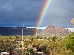
A rainbow appearing after a monsoon in Drexel Heights, Arizona, USA.
|
|

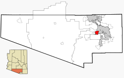
Location in Pima County and the state of Arizona
|
|
| Country | United States |
| State | Arizona |
| County | Pima |
| Area | |
| • Total | 19.25 sq mi (49.85 km2) |
| • Land | 19.25 sq mi (49.85 km2) |
| • Water | 0.00 sq mi (0.00 km2) |
| Elevation | 2,526 ft (770 m) |
| Population
(2020)
|
|
| • Total | 27,523 |
| • Density | 1,429.99/sq mi (552.13/km2) |
| Time zone | UTC-7 (MST (no DST)) |
| FIPS code | 04-20540 |
| GNIS feature ID | 0025237 |
Drexel Heights is a community in Pima County, Arizona, United States. It is a "census-designated place" (CDP). This means it's an area that looks like a town but isn't officially governed as one. In 2020, about 27,523 people lived here.
Contents
How Drexel Heights Got Its Name
The name Drexel Heights is linked to the Drexel family. People once thought it was named after Francis Anthony Drexel. He was a rich financier. He was also the father of Katharine Drexel, who later became a saint.
It was believed that Francis A. Drexel owned land in this area. However, no proof of this has ever been found. He passed away in 1885.
A historian named David Leighton wrote about this in 2014. He said that Drexel Road was named after Saint Katharine Drexel. He also confirmed that her father did not own land here. This suggests that Drexel Heights itself might be named in honor of Saint Katharine Drexel. She was known for setting up missions across the United States.
Geography and Nature
Drexel Heights is located in southern Arizona. It covers an area of about 19.7 square miles (51 square kilometers). All of this area is land.
Local Plants and Animals
The area is home to many Saguaro cacti. These are tall, iconic cacti found in the desert. Drexel Heights is only a few miles south of the Saguaro National Park. This park protects many of these amazing plants.
The northern edge of Drexel Heights borders the Tucson Mountain Park. The Tucson Mountains make it a bit separate from the rest of Tucson. Only a few roads cross these mountains. Ajo Highway is the main route. Gates Pass offers a very scenic drive.
You might also see wild animals like coyotes and javelinas (which look like wild pigs) in the area.
People of Drexel Heights
| Historical population | |||
|---|---|---|---|
| Census | Pop. | %± | |
| 2000 | 23,849 | — | |
| 2010 | 27,749 | 16.4% | |
| 2020 | 27,523 | −0.8% | |
| U.S. Decennial Census | |||
In 2020, the population of Drexel Heights was around 27,523 people. The community has grown over the years. In 2000, about 23,849 people lived here. By 2010, the population increased to 27,749.
Drexel Heights is a diverse community. In 2010, about 70.6% of the people identified as Hispanic or Latino. Many different backgrounds make up the community.
Wildlife in the Community
Drexel Heights has a lot of urban wildlife. This means wild animals live close to people. Sometimes, animals like coyotes or javelinas might wander into neighborhoods.
The local Fire Department sometimes helps with animals that cause problems. They try to release these animals away from town. This helps keep the natural balance. However, sometimes the animals find their way back to where they were first seen.
Education
Students in Drexel Heights attend schools within the Tucson Unified School District.
See also
 In Spanish: Drexel Heights para niños
 | James Van Der Zee |
 | Alma Thomas |
 | Ellis Wilson |
 | Margaret Taylor-Burroughs |


