Drummond, Wisconsin facts for kids
Quick facts for kids
Town of Drummond, Wisconsin
|
|
|---|---|

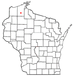
Location of Drummond, Wisconsin
|
|
| Country | |
| State | |
| County | Bayfield |
| Area | |
| • Total | 143.2 sq mi (370.8 km2) |
| • Land | 137.3 sq mi (355.7 km2) |
| • Water | 5.8 sq mi (15.0 km2) |
| Elevation | 1,280 ft (390 m) |
| Population
(2020)
|
|
| • Total | 544 |
| • Density | 3.800/sq mi (1.4671/km2) |
| Time zone | UTC-6 (Central (CST)) |
| • Summer (DST) | UTC-5 (CDT) |
| ZIP code |
54832
|
| Area code(s) | 715 and 534 |
| FIPS code | 55-20887 |
| GNIS feature ID | 1583102 |
Drummond is a small town in Bayfield County, Wisconsin, in the United States. It's a quiet place where about 544 people lived in 2020. The town includes a specific area also called Drummond and another small community named Lake Owen.
Contents
Getting Around Drummond
A major road, U.S. Highway 63, helps people travel through the town. It's the main highway that serves the area.
Geography of Drummond
Drummond covers a total area of about 370.8 square kilometers (or 143.2 square miles). Most of this area is land, about 355.7 square kilometers (137.3 square miles). The rest, about 15.0 square kilometers (5.8 square miles), is water.
People of Drummond
In 2000, there were 541 people living in Drummond. Most of the people were White, with a small number of Native American residents. A very small percentage of the population identified as Hispanic or Latino.
The town had 231 households. Many of these were married couples living together. About 26% of households had children under 18. The average household had about 2.34 people.
The population in Drummond is spread out across different age groups. About 23.1% of the people were under 18 years old. Around 21.8% were 65 years or older. The average age in the town was 44 years old.
Education in Drummond
- Drummond High School is the main high school for students in the town.
See also
 In Spanish: Drummond (Wisconsin) para niños
 | Janet Taylor Pickett |
 | Synthia Saint James |
 | Howardena Pindell |
 | Faith Ringgold |

