Duncans Mills, California facts for kids
Quick facts for kids
Duncans Mills, California
Duncanville
|
|
|---|---|

Duncans Mills museum
|
|
| Country | United States |
| State | California |
| County | Sonoma |
| Elevation | 35 ft (11 m) |
| Population
(2000)
|
|
| • Total | 85 |
| Time zone | UTC-8 (PST) |
| • Summer (DST) | UTC-7 (PDT) |
| ZIP code |
95430
|
| Area code(s) | 707 |
| FIPS code | 06-20130 |
| GNIS feature ID | 222722 |
Duncans Mills (sometimes called Duncan's Mills) is a small, quiet community in Sonoma County, California. It is not a big city, but a charming place with a rich history. This community is located near the beautiful Russian River and the Pacific Ocean.
Contents
History of Duncans Mills
Duncans Mills has a fascinating past. A long time ago, this area was part of a large piece of land. This land was given out by the Mexican government and was known as the Rancho Muniz land grant.
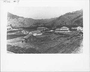
In 1877, a man named Alexander Duncan started a sawmill here. A sawmill is a place where logs are cut into lumber. This mill was very important. It sent wood to help build the growing city of San Francisco. That's how Duncans Mills got its name!
The town grew quickly in the 1870s. It had many important businesses for a small community. There were two hotels, a general store for supplies, and a saloon. It also had a meat market, a blacksmith shop, and a place to keep horses.
Starting in the 1870s, a special narrow-gauge train track ran through Duncans Mills. This was the North Pacific Coast Railroad. It traveled from Cazadero, California all the way to Sausalito. The railroad was sold a few times. Then, it stopped running completely in the 1930s. After the railroad closed, the town slowly became quieter.
However, in 1976, a special project helped bring the town back to life. This project was part of the celebration for the U.S. Bicentennial. Many old buildings were fixed up, and new businesses opened.
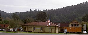
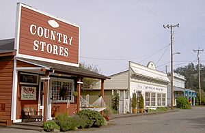
Today, Duncans Mills looks much like it did when it was first built. You can see an original train station building. There are also some old train cars from the historic railroad line. A California State Park office is in a building that looks old, but it was built during the 1976 restoration. The Blue Heron Restaurant has been a popular spot in town for many years.
Geography and Climate
Duncans Mills is located right on the Russian River. It is about 4 miles (6.4 km) away from the Pacific Ocean. The town is also split by State Route 116, a main road.
Climate in Duncans Mills
| Climate data for Duncans Mills, California | |||||||||||||
|---|---|---|---|---|---|---|---|---|---|---|---|---|---|
| Month | Jan | Feb | Mar | Apr | May | Jun | Jul | Aug | Sep | Oct | Nov | Dec | Year |
| Mean daily maximum °F (°C) | 57 (14) |
62 (17) |
65 (18) |
70 (21) |
76 (24) |
81 (27) |
84 (29) |
84 (29) |
82 (28) |
77 (25) |
66 (19) |
57 (14) |
72 (22) |
| Mean daily minimum °F (°C) | 36 (2) |
38 (3) |
40 (4) |
41 (5) |
45 (7) |
48 (9) |
49 (9) |
49 (9) |
48 (9) |
43 (6) |
38 (3) |
34 (1) |
42 (6) |
| Average precipitation inches (mm) | 8.65 (220) |
7.64 (194) |
6.15 (156) |
2.25 (57) |
1.03 (26) |
0.25 (6.4) |
0.08 (2.0) |
0.11 (2.8) |
0.52 (13) |
2.01 (51) |
5.85 (149) |
6.29 (160) |
40.83 (1,037.2) |
The highest temperature ever recorded in Duncans Mills was 113°F (45°C). This happened on July 14, 1972. The lowest temperature ever recorded was 14°F (-10°C). This happened on December 23, 1990.
Population Information
According to a count done in 2000, about 85 people live in Duncans Mills. There are about 129 houses in the area. Some of these houses are empty, and many are used only for vacations or holidays.
 | Kyle Baker |
 | Joseph Yoakum |
 | Laura Wheeler Waring |
 | Henry Ossawa Tanner |


