Dundee, Florida facts for kids
Quick facts for kids
Dundee, Florida
|
|
|---|---|
| Town of Dundee | |

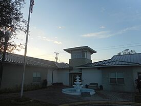
The Dundee Town Hall and Library as seen in January 2022.
|
|

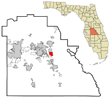
Location in Polk County and the state of Florida
|
|
| Country | United States of America |
| State | Florida |
| County | Polk |
| Settled | 1911 |
| Incorporated | 1925 |
| Named for | Dundee, Scotland |
| Government | |
| • Type | Commission-Manager |
| Area | |
| • Total | 12.13 sq mi (31.41 km2) |
| • Land | 10.78 sq mi (27.91 km2) |
| • Water | 1.35 sq mi (3.50 km2) |
| Elevation | 213 ft (65 m) |
| Population
(2020)
|
|
| • Total | 5,235 |
| • Density | 485.76/sq mi (187.55/km2) |
| Time zone | UTC-5 (Eastern (EST)) |
| • Summer (DST) | UTC-4 (EDT) |
| ZIP code |
33838
|
| Area code(s) | 863 |
| FIPS code | 12-18550 |
| GNIS feature ID | 2406406 |
| Website | http://www.townofdundee.com |
Dundee is a town located in Polk County, Florida, in the United States. In 2020, about 5,235 people lived there. It is part of the larger area that includes Lakeland and Winter Haven.
Contents
History of Dundee
A post office opened in Dundee in 1912. The town got its name from Dundee, a city in Scotland. People first started settling in Dundee in 1911. It officially became a town in 1925.
In April 2024, the people of Dundee voted on whether their town should become a city. Most people, about 68%, voted for Dundee to stay a town. Only 32% voted for it to become a city.
Geography and Climate
Where is Dundee Located?
The town of Dundee is found at these coordinates: 28°00′41″N 81°35′58″W / 28.01139°N 81.59944°W.
Land and Water Area
According to the United States Census Bureau, Dundee covers a total area of about 4.3 square miles (11.1 square kilometers). Most of this area, about 3.9 square miles (10.1 square kilometers), is land. The rest, about 0.4 square miles (1.0 square kilometer), is water. This means about 8.82% of the town's area is water.
Dundee's Climate
Dundee has a humid subtropical climate. This means it has hot, humid summers and mild winters.
Population and People
How Many People Live in Dundee?
The population of Dundee has grown over the years:
- In 1930, there were 615 people.
- By 1950, the population had almost doubled to 1,152.
- In 2000, about 2,912 people lived in Dundee.
- The 2010 census counted 3,717 residents.
- By the 2020 census, the population had increased to 5,235 people.
Who Lives in Dundee?
The 2020 census showed that 5,235 people lived in Dundee. There were 1,416 households, which are groups of people living together. Out of these, 1,218 were families.
The population of Dundee is made up of people from many different backgrounds. In 2020, about 37.34% of residents were White (not Hispanic). About 21.57% were Black or African American (not Hispanic). People of Hispanic or Latino background made up a larger part of the population, at 34.54%. There were also smaller numbers of Native American, Asian, Pacific Islander, and people of two or more races living in the town.
Getting Around Dundee
Major Roads
Several important roads pass through or near Dundee:
- US 27: This is a large highway located just west of town. It connects Dundee to other towns like Lake Wales and Haines City.
- SR 17: This road is known as the "Scenic Highway." It runs right through the middle of Dundee. It's another way to travel across eastern Polk County, running next to US 27.
- SR 542: Also called "Dundee Road," this road starts in downtown Dundee. It goes west to US 27 and continues straight to downtown Winter Haven.
Images for kids
See also
 In Spanish: Dundee (Florida) para niños
 | Leon Lynch |
 | Milton P. Webster |
 | Ferdinand Smith |


