
Dunedin Volcano facts for kids
Quick facts for kids Dunedin VolcanoStratigraphic range: 16-10 Mya |
|
|---|---|
 |
|
| Type | Igneous |
| Overlies | Waipuna Bay Formation |
| Lithology | |
| Primary | Basalt, trachyte, phonolite and breccia |
| Location | |
| Coordinates | 45°50′53″S 170°38′10″E / 45.848°S 170.636°E |
| Region | Otago |
| Country | New Zealand |
| Type section | |
| Named for | Dunedin |

The Dunedin Volcano was a huge shield volcano that erupted a very long time ago, between 16 and 10 million years ago. It's not active anymore! It used to be much bigger, stretching about 25 kilometers from where the city of Dunedin, New Zealand is today, all the way to Aramoana.
Over millions of years, wind and rain have worn it down a lot. Now, Otago Harbour sits where the oldest parts of the volcano used to be. What's left of the volcano forms the hills you see around Otago Harbour. These include famous spots like Mount Cargill, Flagstaff, Saddle Hill, Signal Hill, and the Otago Peninsula.
The volcano started erupting underwater in a shallow sea. It grew bigger as lava, mostly a type called basalt, flowed out. Some trachyte lava also came out. The last eruptions formed special dome-shaped rocks called phonolite, which you can still see near Mount Cargill.
Contents
What is the Dunedin Volcano?
The Dunedin Volcano was a type of volcano called a shield volcano. Imagine a warrior's shield lying on the ground – that's how these volcanoes look! They are wide and gently sloped, not steep and pointy like some other volcanoes.
This volcano had many vents, meaning lava came out from different places. It was active for about six million years, from 16 to 10 million years ago. This was during a time in Earth's history called the Miocene period.
Where was the Dunedin Volcano located?
The volcano was centered near what is now Otago Harbour in New Zealand. Its eruptions created the land that makes up much of the Otago Peninsula and the hills around Dunedin.
Today, the harbor actually fills the oldest parts of the volcano. This shows just how much the landscape has changed over millions of years!
How did the Dunedin Volcano form?
The first eruptions of the Dunedin Volcano happened in a shallow sea. Over time, more and more lava flowed out, building up the volcano. Most of this lava was a dark, common type of volcanic rock called basalt.
As the volcano grew, it also erupted smaller amounts of other types of lava, like trachyte. The very last eruptions produced a different kind of rock called phonolite. These phonolite rocks formed dome shapes, especially around Mount Cargill.
What can we see of the Dunedin Volcano today?
Even though the volcano is long gone, you can still see its traces everywhere in the Dunedin area. It's like finding clues from a giant puzzle!
- The Dunedin Botanic Garden has a special geology walk where you can learn about the volcano's rocks.
- The cliffs at Aramoana show layers of old lava flows.
- Mount Cargill still has preserved lava domes from the volcano's final eruptions.
- You can also see cool rock formations called basaltic columns. These are like giant, natural pillars made of rock. You can find them above Second Beach at St Clair and at Blackhead.
Images for kids
-
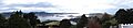
The Dunedin Volcano was originally centred on Quarantine Island (centre of the image) and is now highly eroded. There is speculation that it may have been up to 1000m high.
