
Earl's Sluice facts for kids
Quick facts for kids Earl's Sluice |
|
|---|---|

The culverted mouth of the Earl's Sluice at Deptford Wharf
|
|
| Country | England |
| Counties | Greater London |
| Towns | Deptford |
| Physical characteristics | |
| Main source | Ruskin Park Denmark Hill 51°28′0″N 0°5′33″W / 51.46667°N 0.09250°W |
| River mouth | River Thames Deptford Wharf 51°29′35.19″N 0°1′55.26″W / 51.4931083°N 0.0320167°W |
| Basin features | |
| Tributaries |
|
Earl's Sluice is a river that flows mostly underground in south-east London, England. It begins in Ruskin Park on Denmark Hill. As it travels, it joins another river called the River Peck in South Bermondsey. Finally, it flows into the famous River Thames at Deptford Wharf.
Contents
What is Earl's Sluice?
Earl's Sluice is known as a subterranean river. This means that for most of its journey, it flows hidden beneath the ground. It's one of several such rivers in London that have been covered over as the city grew.
Where Does It Flow?
The river starts its journey in Ruskin Park, which is located on Denmark Hill. From there, it makes its way through various parts of south-east London. In an area called South Bermondsey, it meets and combines with the River Peck. After this meeting, the combined waters continue their flow until they reach the mighty River Thames at Deptford Wharf.
A River with History
Earl's Sluice has a long and interesting history, playing a role in how London developed over the centuries.
How It Got Its Name
The river is named after a powerful person from long ago: the Earl of Gloucester. He lived during the time of King Henry I, who ruled England from 1100 to 1135. The word "sluice" refers to a channel or a gate that controls the flow of water. This suggests that the river's path might have been managed or controlled even in ancient times.
An Old Boundary Marker
For many years, Earl's Sluice served as an important boundary line. It marked the edge between two old church areas, known as parishes. These were St Mary's parish in Rotherhithe and St Paul's parish in Deptford.
Even further back in time, until 1889, the river also marked the boundary between two historic counties: Kent and Surrey. This shows how important natural features like rivers were for defining different regions.
The Earl Pumping Station
There was once a building called the Earl Pumping Station. Its job was to help manage the water from Earl's Sluice and pump it into the River Thames. Although this station has been closed for many years, it played a role in controlling the river's flow and preventing flooding in the past.
Images for kids
-
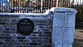
This stone marks the boundary between St Mary's parish, Rotherhithe and St Paul's parish, Deptford. Until 1899 this was also the Kent-Surrey boundary. The stone was on a bridge over the Earl Creek nearby, but was relocated to its present position (on the Thames Path between the confluence of the Sluce and the entrance to South Dock, Rotherhithe in 1988.
-
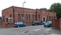
Earl Pumping Station: although closed for years, it processed the water from the Earl's Sluice to the Thames.


