
Bermondsey facts for kids
Quick facts for kids Bermondsey |
|
|---|---|
 St Mary Magdalen Church, Bermondsey |
|

Bermondsey
|
|
| OS grid reference | TQ335795 |
| • Charing Cross | 2.5 mi (4.0 km) WNW |
| London borough | |
| Ceremonial county | Greater London |
| Region | |
| Country | England |
| Sovereign state | United Kingdom |
| Post town | LONDON |
| Postcode district | SE16,SE1,SE15 |
| Dialling code | 020 |
| Police | Metropolitan |
| Fire | London |
| Ambulance | London |
| EU Parliament | London |
| UK Parliament |
|
| London Assembly |
|
Bermondsey is a lively area in southeast London, England. It is part of the London Borough of Southwark. Bermondsey is about 4 kilometers (2.5 miles) southeast of Charing Cross, a famous spot in London.
To its west is Southwark, and to its east are Rotherhithe and Deptford. South of Bermondsey you'll find Walworth and Peckham. Across the River Thames to the north is Wapping. Bermondsey is also within the historic county of Surrey.
During the time of the Industrial Revolution, Bermondsey became a busy center for making things. It was especially known for tanning, which is how leather is made. More recently, the area has been updated. Old warehouses have been turned into cool apartments. New ways to travel around have also been added.
Contents
History of Bermondsey
How Bermondsey Got Its Name
The name Bermondsey might mean Beornmund's island. Beornmund was an Old English person's name. The "-ey" part comes from the Old English word eg. This word means "island," "dry land in a swamp," or just "a place by a river." So, Bermondsey might not have been a true island long ago. It was probably a drier spot in a wet, marshy area.
Bermondsey first appeared in writing in the Domesday Book in 1086. But it might be even older! A very old letter from Pope Constantine (around 708–715 AD) mentions a monastery at Vermundesei. This monastery was connected to Peterborough Abbey.
Early Days: Anglo-Saxons and Normans

The Domesday Book lists Bermondsey as Bermundesy and Bermundesye. It was in the area called the Hundred of Brixton in Surrey. At that time, King William owned most of it. A small part belonged to Robert, Count of Mortain, the king's half-brother.
The Domesday Book said Bermondsey had a "new and handsome church." This church was likely the start of Bermondsey Abbey. The abbey was founded in 1082 by monks. It was dedicated to St Saviour. The monks helped develop the area. They farmed the land and built banks along the river. They also turned a small river inlet into a dock. This dock was called St Saviour's Dock after their abbey.
Back then, Bermondsey was mostly one main street. This street (now Bermondsey Street) led from the Thames up to the abbey. The Knights Templar also owned land here. They gave their name to a famous street called Shad Thames. Other church groups also had land nearby.
Royal Connections in the 1300s
King Edward III built a manor house in Bermondsey in 1353. It was very close to the River Thames. You can still see the old foundations of this house today. They are near Bermondsey Wall East, close to the famous Angel pub.
From Gardens to Spas: 17th & 18th Centuries

Over the years, Bermondsey changed a lot. After the Great Fire of London, many wealthy people moved here. It became like a garden suburb, especially along Grange Road. A fun pleasure garden was built in the 1600s. It is remembered by the Cherry Garden Pier. The famous diarist Samuel Pepys even visited it.
One old building from this time is St Mary Magdalen Church. It was finished in 1690. A church has been on this spot since the 1200s. This church survived the big changes of the 1800s and the Blitz bombings. It is a rare old building in central London.
In the 1700s, a spring was found from the river Neckinger. This led to the creation of Bermondsey Spa. The area between Grange and Jamaica Roads is still called Spa Road today. A new church, St John Horsleydown, was built for the growing number of people.
The Industrial Revolution Arrives
.jpg)
By the mid-1800s, many factories appeared. Famous ones included Alaska chocolate, Salt, cheese, and Hartley's Jam. Parts of Bermondsey, especially by the river, became very crowded and poor. This was due to factories, docks, and new homes for workers. The area around St. Saviour's Dock, called Jacob's Island, was one of the worst places in London.
It was even featured in Charles Dickens's book Oliver Twist. The bad guy, Bill Sikes, dies in the mud of 'Folly Ditch'. Dickens described the area as having:
- ... old wooden walkways behind houses
- Broken windows patched up
- Tiny, dirty rooms with bad air
- Wooden buildings leaning over the mud, threatening to fall
The first passenger railway station in London was built here in 1836. It was part of the London to Greenwich Railway. The first part of the line ran between Spa Road Station and Deptford. This local station closed in 1915.

The industrial growth of the 1800s continued Bermondsey's history of making things. Industries that were too noisy for the City of London moved here. One important industry was processing leather and animal hides. Many old warehouse buildings from this time still stand. You can see them around Bermondsey Street, Tanner Street, and Morocco Street. These include the large Leather Market from 1833. The Leather, Hide and Wool Exchange from 1878 is also there. Most of these buildings are now homes or offices.
Peek, Frean and Co started making biscuits in Bermondsey in 1857. They moved to a bigger factory in 1866. This led to Bermondsey being called 'Biscuit Town'. They baked biscuits here until 1989.
Bermondsey was also home to the world's first food canning business. It was set up in 1812 by Donkin, Hall, and Gamble.
Bermondsey in the 1900s

East of Tower Bridge, Bermondsey's riverside had many warehouses. One of the most famous is Butler's Wharf. These buildings were badly damaged during World War II bombings. They also became unused in the 1960s when river trade stopped.
After being empty for years, many wharves were rebuilt in the 1980s. They are now homes and businesses. These are some of the most expensive properties in London. In 1997, US President Bill Clinton and Prime Minister Tony Blair even ate at a restaurant there.
More regular homes were also built north of the Old Kent Road. This included several council housing areas.

Bermondsey's transport links improved in 2000. The Bermondsey Underground station opened on the London Underground's Jubilee Line Extension. The East London Line also extended as part of the London Overground.
The Blue is the main market place for Bermondsey.
Wee Willie Harris, a famous early rock 'n' roll singer, came from Bermondsey. He used to work at the Peek Freans biscuit factory. He is known as one of the first British rock and roll players.
How Bermondsey is Governed
The London Borough of Southwark Council divides the area into community council areas. Bermondsey is part of the Bermondsey Community Council area. This includes the London Bridge, West Bermondsey, North Bermondsey, and South Bermondsey areas.
Bermondsey's representation in Parliament has changed over time. Since the 1200s, it was part of the Surrey County seat. In 1868, it became part of the Southwark constituency. From 1885 to 1918, Bermondsey had its own separate Member of Parliament.
In 1983, there was a very famous election in Bermondsey. Labour candidate Peter Tatchell lost to Liberal candidate Simon Hughes. This was a huge change in votes. Hughes represented the area until 2015.
Sports in Bermondsey
Millwall Football Club started in 1885. They were formed in Millwall on the Isle of Dogs. Even though they moved across the river to New Cross in 1910, they kept the name. In 1993, they moved to their current stadium, The Den. The team has many local fans. The stadium is very close to Bermondsey, but it is actually in the Borough of Lewisham. The closest train station is South Bermondsey.
Exploring Bermondsey's Geography
Fun Places to Visit
- Maltby Street Market
- Bermondsey antiques market
- Fashion and Textile Museum
- Shad Thames
- Mandela Way T-34 Tank
- Miloco Studios
- Bermondsey Spa Gardens
- Kagyu Samye Dzong, Tibetan Buddhist Centre
- Millwall F.C.
- HMS Belfast
- Rouel Road
- Tower Bridge
Nearby Areas to Explore
- City of London
- Whitechapel
- Borough
- Peckham
- Canary Wharf
- Deptford
- Poplar
- Rotherhithe
- New Cross
- Wapping
- Camberwell
- Walworth
Getting Around Bermondsey
.jpg)
Bermondsey has several train stations. Bermondsey is in London Zone 2. But nearby London Bridge and Borough stations are in Zone 1. You can use Oyster Cards to travel from Bermondsey stations.
London Underground (Tube)
The Jubilee line goes through Bermondsey. It stops at Bermondsey and Canada Water stations. London Bridge station is also nearby. It has the Jubilee and Northern lines. Borough station is on the Northern line.
The Jubilee line connects Bermondsey to Canary Wharf and Stratford. It also goes to Waterloo and the West End. The Northern line from London Bridge goes south to Morden. Northbound trains go through the City of London and King's Cross.
National Rail & London Overground
The East London line, South London line, and South Eastern Main Line all pass through Bermondsey. They offer frequent train connections to Central London and the South East.
London Bridge is the busiest station in the area. It is the fourth busiest in the UK. Trains from London Bridge go to places like Waterloo and Charing Cross. You can also get to Gatwick and Luton airports.
South Bermondsey station has trains to South London. These include direct connections to Beckenham Junction and Crystal Palace.
Rotherhithe, Canada Water and Surrey Quays stations are served by London Overground trains. These connect Bermondsey to Dalston in the north. To the south, they link to New Cross and Clapham Junction.
Queens Road Peckham & Peckham Rye stations are just south of Bermondsey. Peckham Rye also has trains to London Victoria station.
Bus Connections
Many London Buses routes serve Bermondsey. These include routes 1, 42, 47, 78, 188, 381, C10, and P12. There are also night bus routes like N1, N47, N199, and N381.
Roads in Bermondsey
Several main roads go through Bermondsey. These include:
- The A100 (Tower Bridge Road) – goes towards the City of London.
- The A101 (Rotherhithe Tunnel) – goes to Limehouse and Canary Wharf.
- The A2 (Great Dover Street/Old Kent Road) – goes towards Kent.
- The A200 (Jamaica Road/Lower Road) – goes to London Bridge.
- The A202 (New Kent Road) – goes towards Elephant & Castle.
The Bricklayer's Arms is a very busy road junction here.
The southern entrance of the Rotherhithe Tunnel (A101) is in Bermondsey. This tunnel was finished in 1908. It carries cars from Bermondsey to the East End.
Air Pollution
Local officials say that car fumes are the main cause of air pollution in Southwark. Air pollution levels are checked in Bermondsey. In 2017, Bermondsey had some of the highest nitrogen dioxide (NO2) levels. This was especially true near the Rotherhithe Tunnel and on Jamaica Road. All these areas did not meet national air quality goals.
Cycling in Bermondsey
Bermondsey is well connected to London's cycle routes. Several marked routes pass through the area. Most of these routes go from east to west.
| Route | Westbound | Eastbound | Notes |
|---|---|---|---|
|
|
London Bridge, Bankside | Rotherhithe | NCN 4 runs across Bermondsey. It uses mostly quiet streets or shared paths. |
| National Cycle Route 425 (NCN 425) | Camberwell | Rotherhithe | NCN 425 runs from southwest to northeast. It uses quiet streets or shared paths. |
| EuroVelo 2 – "The Capitals Route" (EV2) | London Bridge, Bankside | Rotherhithe, Greenwich | EV2 follows NCN 4 through Bermondsey. It is part of a large European cycle network. |
| Cycle Superhighway 4 (CS4) – Under Construction | Tower Bridge | Deptford, Greenwich | Transport for London is building a special two-way cycle track here. Work started in 2019. |
| Quietway 1 (Q1) | Borough | Deptford | Q1 uses quiet streets and roads. It passes south of South Bermondsey railway station. |
| Quietway 14 (Q14) | Borough | Rotherhithe, Canada Water | Q14 uses quiet streets and roads. It is a marked route. |
The Santander Cycles bike sharing scheme came to Bermondsey in 2020. Five new docking stations were added.
Images for kids
-
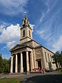
The Church of Saint James in Bermondsey, built in the 1820s.

.jpg)
See also
 In Spanish: Bermondsey para niños
