
River Neckinger facts for kids

The River Neckinger is a small, mostly underground river in London. It starts in Southwark and flows about 2.5 kilometers (1.5 miles) before joining the River Thames at St Saviour's Dock. Most of this river now runs hidden beneath the streets. Its water is mostly sent into other underground pipes and sewers.
Contents
What is the River Neckinger?
The Neckinger is a historic waterway that once flowed openly through parts of South London. Over time, as London grew, the river was covered up and now runs underground. It's a great example of a "lost" river, meaning it's still there, but you can't see it on the surface anymore.
Where Does the Neckinger Flow?

The Neckinger used to drain wet areas in what is now Geraldine Mary Harmsworth Park in Southwark. It flowed east, following paths like Brook Drive. It passed by famous places like the Elephant and Castle.
An early part of the river was known as the Lock Stream. This was because it flowed near the old Lock Hospital. The river then passed south of the historic Bermondsey Abbey. It formed a channel north of what was once a large island in the Thames called Bermond's ey. Today, Abbey Street follows a similar path to this old channel.
In ancient times, the river had at least three wide mouths that connected to the Thames. Two were west of the small island of Horsleydown. The third was near where St Saviour's Dock is now. The Neckinger's northern mouth, which is now an underground pipe, separates the areas of Shad Thames and Jacob's Island. These areas were once marshland but are now built up with buildings.
The Neckinger's Interesting History
How Did the River Get Its Name?
The name "Neckinger" has a dark but interesting past. In the 1600s, a wharf where the river met the Thames was a place where convicted pirates faced punishment. People believe the name comes from "devil's neckcloth," which was a slang term for a hangman's noose.
In 1891, historian Henry B. Wheatley wrote that there was good evidence that the "Devil's Neckinger" was an old place of punishment. It was located near a pub called the "Dead Tree public-house" on Jacob's Island. Other writers in 1888 also noted that a map from 1740 showed a place called "Devol's Neckenger" in the same spot as the Dead Tree inn.
Canute's Trench: An Ancient Connection

Some historians, like Walter Besant, say that an early part of the Neckinger was known as Canute's Trench. This was where it crossed the Old Kent Road at Lock Bridge. In May 1016, Cnut the Great, a Danish king who had invaded England, dug a trench through Southwark. This allowed his boats to get around the heavily defended London Bridge. Later, in 1173, a similar channel was used to drain water from the Thames. This helped with building work on London Bridge.
The Neckinger in the Middle Ages
In the 1300s, the spot where the Neckinger crossed the Old Kent Road was called the wateryng of Seint Thomas. This means "the watering place of Saint Thomas." It was also known as St. Thomas-à-Watering. Geoffrey Chaucer mentioned this place in his famous book, The Canterbury Tales. It was where pilgrims would water their horses on their way to visit Thomas Becket's shrine. Later, in the Tudor period, St. Thomas-à-Watering also became a place for public executions.
In the 1500s, a plant expert named John Gerard wrote about a "wild willow herb." He said it was found near the execution place at St. Thomas a Watering. He also mentioned it by a path near the "Devil's Neckerchief" on the way to Redriffe.

During the Middle Ages, the local religious group, Bermondsey Abbey, used the Neckinger's water. They used it to power a Tide mill. This mill's early name was Redriff, which was also an old name for the nearby area of Rotherhithe. In 1536, the Abbey leased the mill to John Curlew. However, the Dissolution of the Monasteries meant the mill was later bought by private owners. At this time, boats could travel on the Neckinger from the Thames all the way up to the Abbey grounds.
A local doctor, William Rendle, wrote in 1878 about a bridge on the Old Kent Road. This bridge dated back to the time of Bermondsey Abbey. It was still visible as part of the sewer system in the 1800s. It was a pointed stone arch with six ribs, similar to old parts of London Bridge. Its date might have been around the mid-1400s. The bridge was 20 feet wide, and its arch was 9 feet across.
In 1640, the City of London ordered the Lock Bridge to be fixed as part of sewer work. Rendle said that sewers were built next to the bridge on each side. It was a well-known landmark for "sewer people" working in the tunnels. Even when improvements were made in the 1800s, this old bridge was not damaged. It was simply covered up again.
The Neckinger in the 1700s and 1800s
Private homes and businesses started to be built on the old Abbey lands. The Neckinger's water attracted tanners, who used it to process leather. In the late 1700s, there was a disagreement over who could use the water. The tanners sued the mill owner and won. They argued that local people had an old right to use the tidal water.

The Jacob's Island area, near the Neckinger, was known for being very poor and crowded from the early 1800s until the mid-1900s. Charles Dickens described it in 1838 as "the filthiest, the strangest, the most extraordinary of the many localities that are hidden in London." In his famous novel, Oliver Twist, a part of the Neckinger is called Folly Ditch. This is where the character Bill Sikes meets his end.
In the 1790s, the Neckinger Mill was built to make paper. This continued until 1805, when the land was sold to Bevingtons, a leather manufacturing company. In 1838, a new railway line for the London and Greenwich Railway split the mill's land into two parts. More railway work happened in 1841 and 1850.
The Neckinger in Modern Times
In 1935, Bevingtons moved most of their business to Dartford. They kept the smaller part of their land as a warehouse. They sold the larger part to the Bermondsey Borough Council. When Bevingtons sold the warehouse in the early 1980s, it was turned into homes. Since then, new luxury apartments have been built nearby. These new buildings exist alongside the unique houseboats moored at Reed Wharf.
Images for kids
-
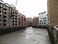
St Saviour's Dock is a deep-excavated and embanked inlet where the vestiges of the Neckinger meet the River Thames. Here the inlet divides the riverside districts of Shad Thames and Jacob's Island.
-
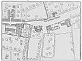
19th century map showing the Lock Stream (between the Lock Hospital and Bull Inn) going under the Old Kent Road then reappearing as a channel on the other side.
-
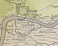
Route of Canute's Trench south of the River Thames from A History of London (1884) by W. J. Loftie. The early section of the Neckinger, where it crossed the Old Kent Road, was known by this name.
-
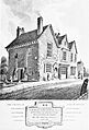
1813 engraving of Chapel of the Hospital for Lepers in Kent Street, Southwark, called Le Lock. The upper section of the Neckinger passed by the hospital site and was known as Lock Stream.
-
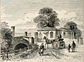
1820 engraving of the bridge and turnpike of Grange Road (now Grange Walk) over the River Neckinger.
