East Liberty, Ohio facts for kids
Quick facts for kids
East Liberty, Ohio
|
|
|---|---|

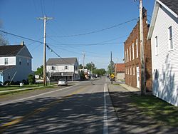
Buildings in central East Liberty
|
|

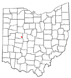
Location of East Liberty, Ohio
|
|
| Country | United States |
| State | Ohio |
| County | Logan |
| Township | Perry |
| Area | |
| • Total | 1.58 sq mi (4.09 km2) |
| • Land | 1.58 sq mi (4.09 km2) |
| • Water | 0.00 sq mi (0.00 km2) |
| Elevation | 1,119 ft (341 m) |
| Population
(2020)
|
|
| • Total | 371 |
| • Density | 235.26/sq mi (90.80/km2) |
| Time zone | UTC-5 (Eastern (EST)) |
| • Summer (DST) | UTC-4 (EDT) |
| ZIP code |
43319
|
| FIPS code | 39-23702 |
| GNIS feature ID | 2628888 |
East Liberty is a small community in Logan County, Ohio, in the United States. It is known as an "unincorporated community." This means it's a place with a shared identity, but it doesn't have its own local government like a city or town. It's also a "census-designated place" (CDP), which means the U.S. Census Bureau counts its population separately.
In 2020, about 371 people lived in East Liberty. You can find it near U.S. Route 33, about 10 miles (16 km) east of Bellefontaine. It's also about 46 miles (74 km) northwest of Columbus. East Liberty has its own post office with the ZIP code 43319.
Contents
History of East Liberty
East Liberty was officially planned and marked out in 1834. A post office opened in the community shortly after, in 1836.
In 1882, a college called Central Ohio College was started in East Liberty. It was formally established the next year. The college did well for a while, but it faced money problems and had to close in the late 1890s.
Important Places in East Liberty
East Liberty is home to some big and important facilities. One of the most well-known is a large Honda car factory. This factory, called the East Liberty Auto Plant, started making cars in 1989.
The community also has the Vehicle Research and Testing Center. This center belongs to the National Highway Traffic Safety Administration (NHTSA). It's located at a special testing area called the Transportation Research Center. Here, they test vehicles to make sure they are safe.
Besides U.S. Route 33, other important roads in East Liberty include State Route 292 and State Route 347.
Where is East Liberty Located?
East Liberty is in the southern part of Perry Township. It covers an area of about 1.58 square miles (4.1 square kilometers). All of this area is land. A small stream called Otter Creek flows through the southern part of the community. This creek eventually flows into Mill Creek, which then joins the Scioto River.
Who Lives in East Liberty?
| Historical population | |||
|---|---|---|---|
| Census | Pop. | %± | |
| 2020 | 371 | — | |
| U.S. Decennial Census | |||
According to the 2020 census, the population of East Liberty was 371 people.
See also

- In Spanish: East Liberty (Ohio) para niños
 | William Lucy |
 | Charles Hayes |
 | Cleveland Robinson |

