East Newnan, Georgia facts for kids
Quick facts for kids
East Newnan, Georgia
|
|
|---|---|

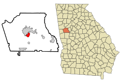
Location in Coweta County and the state of Georgia
|
|
| Country | United States |
| State | Georgia |
| County | Coweta |
| Area | |
| • Total | 2.92 sq mi (7.56 km2) |
| • Land | 2.83 sq mi (7.32 km2) |
| • Water | 0.09 sq mi (0.24 km2) |
| Elevation | 906 ft (276 m) |
| Population
(2020)
|
|
| • Total | 1,022 |
| • Density | 361.64/sq mi (139.61/km2) |
| Time zone | UTC-5 (Eastern (EST)) |
| • Summer (DST) | UTC-4 (EDT) |
| FIPS code | 13-25692 |
| GNIS feature ID | 0331623 |
East Newnan is a small community in Coweta County, Georgia, in the United States. It's known as an unincorporated community, which means it doesn't have its own local government like a city does. It's also a census-designated place (CDP), which is an area that the government counts for population surveys. In 2020, about 1,022 people lived in East Newnan.
Where is East Newnan?
East Newnan is located near the middle of Coweta County. It's right next to the city of Newnan, which is the main town in the county.
You can find East Newnan at these coordinates: 33°20′58″N 84°46′39″W / 33.34944°N 84.77750°W. Major roads like U.S. Route 29 and Interstate 85 are close by. Interstate 85 runs along the eastern side of East Newnan.
The total area of East Newnan is about 7.7 square kilometers (2.92 square miles). Most of this area is land, but a small part, about 0.2 square kilometers (0.09 square miles), is water.
People and Population
The number of people living in East Newnan has changed over the years. The U.S. Census counts how many people live in different areas every ten years.
| Historical population | |||
|---|---|---|---|
| Census | Pop. | %± | |
| 1970 | 1,634 | — | |
| 1980 | 1,495 | −8.5% | |
| 1990 | 1,173 | −21.5% | |
| 2000 | 1,305 | 11.3% | |
| 2010 | 1,321 | 1.2% | |
| 2020 | 1,022 | −22.6% | |
| U.S. Decennial Census | |||
Here's a look at the different groups of people who have lived in East Newnan over time. This table shows the racial and ethnic makeup of the community.
| Race / Ethnicity (NH = Non-Hispanic) | Pop 2000 | Pop 2010 | Pop 2020 | % 2000 | % 2010 | % 2020 |
|---|---|---|---|---|---|---|
| White alone (NH) | 866 | 618 | 490 | 66.36% | 46.78% | 47.95% |
| Black or African American alone (NH) | 304 | 242 | 229 | 23.30% | 18.32% | 22.41% |
| Native American or Alaska Native alone (NH) | 4 | 0 | 2 | 0.31% | 0.00% | 0.20% |
| Asian alone (NH) | 0 | 1 | 5 | 0.00% | 0.08% | 0.49% |
| Pacific Islander alone (NH) | 3 | 0 | 0 | 0.23% | 0.00% | 0.00% |
| Some Other Race alone (NH) | 0 | 4 | 7 | 0.00% | 0.30% | 0.68% |
| Mixed Race or Multi-Racial (NH) | 12 | 24 | 51 | 0.92% | 1.82% | 4.99% |
| Hispanic or Latino (any race) | 116 | 432 | 238 | 8.89% | 32.70% | 23.29% |
| Total | 1,305 | 1,321 | 1,022 | 100.00% | 100.00% | 100.00% |
East Newnan was first recognized as an unincorporated place in 1970. It became a census-designated place (CDP) in 1980. Its population in 2020 was 1,022 people.
See also
 In Spanish: East Newnan para niños

