Newnan, Georgia facts for kids
Quick facts for kids
Newnan, Georgia
|
|||||
|---|---|---|---|---|---|

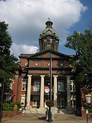
Coweta County Courthouse
|
|||||
|
|||||
| Motto(s):
City of Homes
|
|||||

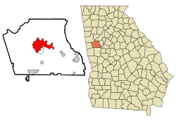
Location in Coweta County and the state of Georgia
|
|||||
| Country | United States | ||||
| State | Georgia | ||||
| County | Coweta | ||||
| Incorporated (city) | December 20, 1828 | ||||
| Area | |||||
| • Total | 19.82 sq mi (51.34 km2) | ||||
| • Land | 19.48 sq mi (50.44 km2) | ||||
| • Water | 0.35 sq mi (0.90 km2) | ||||
| Elevation | 971 ft (296 m) | ||||
| Population
(2020)
|
|||||
| • Total | 42,549 | ||||
| • Density | 2,184.80/sq mi (843.58/km2) | ||||
| Time zone | UTC−5 (Eastern (EST)) | ||||
| • Summer (DST) | UTC−4 (EDT) | ||||
| ZIP Codes |
30263–30265, 30271
|
||||
| Area code(s) | 770, 678 | ||||
| FIPS code | 13-55020 | ||||
| GNIS feature ID | 0332499 | ||||
Newnan is a city in Georgia, located about 40 miles (64 km) southwest of Atlanta. It is the main city and county seat of Coweta County. In 2020, about 42,549 people lived there. This was an increase from 33,039 people in 2010.
Contents
History of Newnan
Newnan became the main town of Coweta County in 1828. It was named after General Daniel Newnan from North Carolina. The city quickly grew and attracted many professionals like lawyers and doctors, as well as merchants. Newnan became wealthy because of its cotton industry.
During the Civil War, Newnan was mostly saved from damage. This was because it was used as a hospital city for Confederate soldiers. Because of this, many old buildings from before the war are still standing today. These buildings are known for their beautiful antebellum architecture. A famous architect named Kennon Perry designed many homes in the city during the 1900s.
Newnan is home to a special museum that focuses on African American history. It's called the Coweta County African American Heritage Museum and Research Center, also known as the Caswell House. It opened in 2003 in a house that used to belong to Ruby Caswell. The museum is located on Farmer Street, on what was once an unmarked cemetery for enslaved people. The museum has collected many family records by talking to local residents and looking at old census documents. It also has census information for Coweta County from 1870 to 1920.
The first library for Black people in the county was the Sara Fisher Brown Library. It was built in the 1950s. Today, this building is used as the Community Action For Improvement Center.
The Farmer Street Cemetery is a very important historical site. It is believed to be the largest cemetery for enslaved people in the Southern United States. It might even be the largest undisturbed one in the entire country. This cemetery is located right within Newnan's city limits.
Geography and Climate
Newnan is located in the middle of Coweta County. U.S. Route 29 goes through the city center. This road leads northeast to Palmetto and south to Moreland. Interstate 85 runs along the eastern side of Newnan. You can get on or off I-85 at exits 41 and 47. I-85 goes northeast to downtown Atlanta and southwest to Montgomery, Alabama.
Newnan covers a total area of about 19.82 square miles (51.34 square kilometers). Most of this area is land, with a small part being water.
Newnan's Weather
| Climate data for Newnan, Georgia | |||||||||||||
|---|---|---|---|---|---|---|---|---|---|---|---|---|---|
| Month | Jan | Feb | Mar | Apr | May | Jun | Jul | Aug | Sep | Oct | Nov | Dec | Year |
| Mean daily maximum °F (°C) | 52 (11) |
58 (14) |
65 (18) |
73 (23) |
80 (27) |
86 (30) |
89 (32) |
88 (31) |
83 (28) |
73 (23) |
64 (18) |
55 (13) |
72 (22) |
| Mean daily minimum °F (°C) | 31 (−1) |
33 (1) |
40 (4) |
47 (8) |
56 (13) |
64 (18) |
68 (20) |
67 (19) |
62 (17) |
49 (9) |
41 (5) |
33 (1) |
49 (10) |
| Average precipitation inches (mm) | 5.49 (139) |
5.14 (131) |
5.95 (151) |
4.17 (106) |
4.37 (111) |
3.99 (101) |
4.66 (118) |
4.00 (102) |
3.24 (82) |
2.86 (73) |
4.18 (106) |
4.27 (108) |
52.32 (1,329) |
| Average snowfall inches (cm) | 0.8 (2.0) |
0.5 (1.3) |
0.4 (1.0) |
0.1 (0.25) |
0 (0) |
0 (0) |
0 (0) |
0 (0) |
0 (0) |
0 (0) |
0 (0) |
0.2 (0.51) |
2 (5.06) |
| Source: The Weather Channel | |||||||||||||
Population of Newnan
| Historical population | |||
|---|---|---|---|
| Census | Pop. | %± | |
| 1860 | 2,546 | — | |
| 1870 | 1,917 | −24.7% | |
| 1880 | 2,006 | 4.6% | |
| 1890 | 2,859 | 42.5% | |
| 1900 | 3,654 | 27.8% | |
| 1910 | 5,548 | 51.8% | |
| 1920 | 7,037 | 26.8% | |
| 1930 | 6,386 | −9.3% | |
| 1940 | 7,182 | 12.5% | |
| 1950 | 8,218 | 14.4% | |
| 1960 | 12,169 | 48.1% | |
| 1970 | 11,205 | −7.9% | |
| 1980 | 11,449 | 2.2% | |
| 1990 | 12,497 | 9.2% | |
| 2000 | 16,242 | 30.0% | |
| 2010 | 33,039 | 103.4% | |
| 2020 | 42,549 | 28.8% | |
| U.S. Decennial Census | |||
| Race | Number | Percent |
|---|---|---|
| White (non-Hispanic) | 21,206 | 49.84% |
| Black or African American (non-Hispanic) | 13,033 | 30.63% |
| Hispanic or Latino | 4,521 | 10.63% |
| Asian | 1,879 | 4.42% |
| Other/mixed | 1,819 | 4.28% |
| Native American | 69 | 0.16% |
| Pacific Islander | 22 | 0.05% |
In 2020, there were 42,549 people living in Newnan. There were 15,135 households and 10,013 families.
Education in Newnan
Coweta County School District
The Coweta County School District serves students from preschool all the way to 12th grade. The district has 19 elementary schools, seven middle schools, and three high schools. More than 18,389 students attend schools in the district, taught by 1,164 full-time teachers.
Elementary Schools
- Arbor Springs Elementary
- Arnco-Sargent Elementary
- Atkinson Elementary
- Brooks Elementary
- Canongate Elementary
- Eastside Elementary
- Elm Street Elementary
- Grantville Elementary
- Jefferson Parkway Elementary
- Moreland Elementary
- Newnan Crossing Elementary
- Northside Elementary
- Poplar Road Elementary
- Ruth Hill Elementary
- Thomas Crossroads Elementary
- Western Elementary
- Welch Elementary
- White Oak Elementary
- Willis Road Elementary
- The Heritage School (private)
- Trinity Christian School (private)
Middle Schools
- Arnall Middle School
- Blake Bass Middle School
- East Coweta Middle School
- Evans Middle School
- Lee Middle School
- Madras Middle School
- Smokey Road Middle School
- The Heritage School (private)
- Trinity Christian School (private)
- Odyssey Charter School
High Schools
- Newnan High School
- East Coweta High School
- Northgate High School
- Central Educational Center (Chartered Coweta County School System School)
- The Pentecostal Church of God Christian Academy (private)
- The Heritage School (private)
- Trinity Christian School (private)
Colleges and Universities
Mercer University has a learning center in Newnan that opened in 2010. It offers programs for adults who want to continue their education.
The University of West Georgia also has a campus in Newnan, close to downtown. This campus offers two bachelor's degree programs: one in nursing and one in early childhood education.
Newnan is also home to a campus of West Georgia Technical College, which provides technical training.
In the past, from 1854 to 1888, there was a school for women called College Temple. It was a non-religious school.
Transportation in Newnan
Major Roads
- Interstate 85
- Outer Perimeter
- State Route 34
- State Route 34 Bypass
- State Route 16
- State Route 70
- Lower Fayetteville Road
- Newnan Crossing Boulevard East
- Newnan Crossing Bypass
- U.S. Route 29
- U.S. Route 27 Alternate
Public Transport
A public trolley runs between downtown Newnan and The Forum at Ashley Park shopping area.
Walking and Biking Paths
- LINC
Airports
- The Newnan–Coweta County Airport offers private plane services and flight lessons.
Train Services
In the past, Newnan was a stop for passenger trains. Until the mid-1950s, the Central of Georgia railway ran two daily trains, called the Man O' War, between Atlanta and Columbus, stopping in Newnan. The Southern Railway's Crescent train, which traveled from New Orleans to New York City, also stopped in Newnan until 1970.
Famous People from Newnan
Many notable people have connections to Newnan:
- Ellis Arnall: A former governor of Georgia (1943–1947).
- William Yates Atkinson: Another former governor of Georgia (1894–1898).
- Karsten Bailey: A former wide receiver in the National Football League (NFL) for the Seattle Seahawks and Green Bay Packers.
- Cam Bedrosian: A pitcher in Major League Baseball (MLB) for the Los Angeles Angels.
- Steve Bedrosian: A former MLB pitcher who won the Cy Young Award in 1987.
- Hamilton Bohannon: A musician and record producer.
- Keith Brooking: A former linebacker for the NFL's Atlanta Falcons and Dallas Cowboys.
- Erskine Caldwell: A famous novelist and short story writer (1903–1987).
- Jack Tarpley Camp Jr.: A judge.
- Lewis Grizzard: An author and newspaper writer.
- Drew Hill: A former NFL wide receiver for the Houston Oilers, Los Angeles Rams, and Atlanta Falcons.
- Alan Jackson: A member of the Country Music Hall of Fame.
- Joe M. Jackson: A United States Air Force colonel and a recipient of the Medal of Honor.
- Calvin Johnson: A former All-Pro NFL wide receiver for the Detroit Lions.
- John Keith: A former NFL player.
- Wil Lutz: An NFL kicker for the New Orleans Saints.
- Mary Lyndon: The first woman to earn a degree from the University of Georgia.
- Monica: A Grammy-winning singer, songwriter, actress, and businesswoman.
- Warren Newson: An MLB player for the Chicago White Sox and Texas Rangers.
- Alec Ogletree: An NFL linebacker.
- Stephen W. Pless: A Marine Corps major and a recipient of the Medal of Honor.
- Ralph Presley: An airline pilot and politician.
- Rocky Roquemore: An international golf course designer.
- Jefferson Randolph "Soapy" Smith II: (1860–1898), a well-known gambler and con man from the 19th century.
- Lynn Smith: A businesswoman, educator, and politician.
- Will Smith: An MLB pitcher for the Kansas City Royals.
- Doug Stone: A country music singer-songwriter.
- Charles Wadsworth: A concert pianist and music promoter.
- Jerome Walton: An MLB player who won the Rookie of the Year award in 1989.
- Marie Robinson Wright: (1853–1914), a journalist, traveler, historian, and author.
- William C. Wright: A congressman (1918–1933).
- Steve Young: A pioneer country rock musician.
Newnan in Movies and TV
Newnan has been a filming location for several movies and TV shows:
- The ABC TV series October Road was filmed in Newnan, but the story was set in a made-up town in Massachusetts.
- The TV movie Murder in Coweta County (1983) was based on real events from around 1948.
- The NBC series I'll Fly Away was filmed in Newnan from 1991 to 1993.
- The 1995 movie Fluke was filmed here.
- Pet Sematary Two (1992)
- The 1979 movie The Sheriff and the Satellite Kid with Bud Spencer was filmed and takes place in Newnan.
- The TV series The Walking Dead filmed several scenes in Newnan, including at Newnan High School and Sonrise Baptist Church.
- The Netflix TV series Insatiable was filmed in Newnan.
- Zombieland (2009)
- The Hunger Games: Mockingjay – Part 1 (2014)
- The Founder (2016)
- The House with a Clock in Its Walls (2018)
- Lovecraft Country (2019)
- Jumanji: The Next Level (2019) was filmed in Newnan. Fake snow was used to create a winter storm effect downtown. A local business, Rock Salt Milk Bar, was used as "Nora's Diner" in the movie.
See also
 In Spanish: Newnan para niños
 | Janet Taylor Pickett |
 | Synthia Saint James |
 | Howardena Pindell |
 | Faith Ringgold |


