East Richford–Glen Sutton Border Crossing facts for kids
Quick facts for kids East Richford-Glen Sutton Border Crossing |
|
|---|---|

Canada Border Station at Glen Sutton
|
|
| Location | |
| Country | United States; Canada |
| Location |
|
| Coordinates | 45°00′43″N 72°35′17″W / 45.01183°N 72.588193°W |
| Details | |
| Opened | 1926 |
| US Phone | (802) 848-7746 |
| Canadian Phone | (450) 538-3234 |
| Hours | Open 8 AM to 4 PM US / 8 AM to 4PM Canada |
|
U.S. Inspection Station-East Richford, Vermont
|
|
| MPS | U.S. Border Inspection Stations MPS |
| NRHP reference No. | 14000604 |
| Added to NRHP | September 10, 2014 |
The East Richford–Glen Sutton Border Crossing is a special place where you can cross the border between Canada and the United States. It connects two towns: Sutton, Quebec in Canada and Richford, Vermont in the US. Long ago, in the early 1900s, this road was a very important path for people traveling between the east and west.
The United States built a big border station here in 1936. This building is still used today and is listed on the National Register of Historic Places. This means it's a very important historical site. The actual border crossing happens on the Missisquoi River Bridge. This bridge was built in 1929 and is also a historic landmark. The first bridge, built in 1926, was washed away just one year later by a huge flood in 1927. Both the US and Canadian border stations are open every day from 8:00 AM to 4:00 PM.
Contents
Where is the Border Crossing?
This border crossing is in a quiet, country area. The border itself is a straight line that runs from east to west. The Missisquoi River flows across this border, moving from Quebec in Canada into Vermont in the US.
The Missisquoi River Bridge
The actual crossing point is on the Missisquoi River Bridge. This bridge is made of metal and was built in 1929. It replaced an older bridge that was destroyed by a flood in 1927.
The Canadian Side
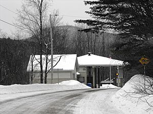
On the Canadian side, you'll find a peaceful, wooded area. The border station is the only building right near the crossing. A smaller road and train tracks run next to the river on the east side. Missisquoi Valley Road, where the Canadian border station is, runs next to the river on the west side.
The United States Side
The US side is also rural, with the small village of East Richford located just east of the river. The train tracks continue to follow the river as it flows southwest. Vermont Route 105A also runs parallel to the river on this side.
The United States Border Station
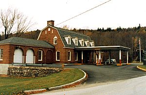
The US border station is located where Vermont Route 105A makes a turn. The river is to its west, and a small stream called Lucas Brook is to its south. This station is a two-story building made of brick. It has a classic style, with a special roof shape called a gambrel roof.
Building Design and Features
The main part of the building has five sections. In the middle, there's an entrance that leads to separate areas for checking people (immigration) and goods (customs). A covered driveway, called a porte-cochere, extends from the center of the building. This provides shelter for two lanes of traffic. On each side of the main building, there are single-story wings with four garage bays. Some of these garage bays have been changed into living spaces.
History of the US Station
This station was built in 1931. It received money from the Public Works Administration, a government program that created jobs during the Great Depression. This station was one of three similar border stations built in Vermont during the 1930s. It was designed to handle a lot of traffic because this was a busy crossing point. The US government built these stations to improve border security. This was important because more people were traveling by car, and there was an increase in smuggling during a time when certain goods were not allowed.
The Canada Station
The Canadian station is located on the southeast side of Missisquoi Valley Road. It's a short distance north of the bridge. Canada built a new border station here in 1960.
 | Janet Taylor Pickett |
 | Synthia Saint James |
 | Howardena Pindell |
 | Faith Ringgold |


