Eastville, Virginia facts for kids
Quick facts for kids
Eastville, Virginia
|
|
|---|---|

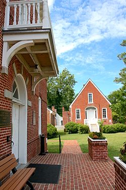
The historic court green in Eastville.
|
|

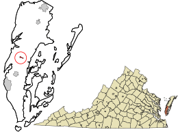
Location in Northampton County and the state of Virginia.
|
|
| Country | United States |
| State | Virginia |
| County | Northampton |
| Area | |
| • Total | 0.79 sq mi (2.06 km2) |
| • Land | 0.79 sq mi (2.04 km2) |
| • Water | 0.01 sq mi (0.02 km2) |
| Elevation | 30 ft (9 m) |
| Population
(2020)
|
|
| • Total | 300 |
| • Density | 381.7/sq mi (147.4/km2) |
| Time zone | UTC−5 (Eastern (EST)) |
| • Summer (DST) | UTC−4 (EDT) |
| ZIP code |
23347
|
| Area code(s) | 757, 948 |
| FIPS code | 51-24752 |
| GNIS feature ID | 1498474 |
| Website | Official website: http://eastville.esva.net/ |
Eastville is a small town located in Northampton County, Virginia, in the United States. In 2020, about 300 people lived there. It is the main town, or county seat, of Northampton County. The historic court area in Eastville is a special place. It is part of the Eastville Historic District.
Contents
Geography of Eastville
Eastville is found at coordinates 37°21′3″N 75°56′24″W / 37.35083°N 75.94000°W. This means it's in a specific spot on the map.
The town covers a total area of about 0.8 square miles (2.0 square kilometers). Almost all of this area is land.
Population and People
| Historical population | |||
|---|---|---|---|
| Census | Pop. | %± | |
| 1900 | 313 | — | |
| 1910 | 322 | 2.9% | |
| 1920 | 332 | 3.1% | |
| 1930 | 351 | 5.7% | |
| 1940 | 316 | −10.0% | |
| 1950 | 311 | −1.6% | |
| 1960 | 261 | −16.1% | |
| 1970 | 203 | −22.2% | |
| 1980 | 238 | 17.2% | |
| 1990 | 185 | −22.3% | |
| 2000 | 203 | 9.7% | |
| 2010 | 305 | 50.2% | |
| 2020 | 300 | −1.6% | |
| U.S. Decennial Census | |||
According to the census in 2000, there were 203 people living in Eastville. These people lived in 69 households, and 42 of these were families.
About 17% of the people were under 18 years old. Around 18% were 65 years old or older. The average age in the town was 41 years.
History of Eastville
Eastville is located near some of the very first European settlements in this part of Virginia. In 1620, a person named Thomas Savage helped the Virginia Company get land from the Native American groups living there. He settled on land that later became known as “Savage Neck.” This area is a few miles southwest of where Eastville is today.
Later, in the late 1600s, Henry Matthews settled on the land where the town now stands. In 1677, people in Northampton County asked for the county court to be moved to a more central spot. They suggested Matthew's home. The first courthouse was finished in 1690. A small community grew around it, called “The Horns.” This name came from the peninsulas of land that stretched into the Chesapeake Bay.
Almost a century later, in 1773, the town was officially planned and named Northampton Court House. The late 1700s and early 1800s saw a lot of growth. A third courthouse was built in 1795. A tavern and several large homes were also built. Some of these homes, like Cessford, Park Hall, and Ingleside, are still important parts of the town's history today. These homes show off old building styles called Georgian and Federal architecture. The town was known as Northampton Court House and Peachburg until it was officially named Eastville around 1800.
Getting Around Eastville
Main Roads
 US 13
US 13
 US 13 Bus.
Public Transport
STAR Transit offers public transit services in the area. This service connects Eastville with other towns like Cape Charles and Onley. It also links Eastville to other communities in Northampton and Accomack counties on the Eastern Shore.
See also
 In Spanish: Eastville para niños
 | Toni Morrison |
 | Barack Obama |
 | Martin Luther King Jr. |
 | Ralph Bunche |

