Echo Bay (Long Island Sound) facts for kids
Quick facts for kids Echo Bay |
|
|---|---|

Echo Bay and Harbor Management Area
|
|
| Location | New Rochelle, New York |
| Coordinates | 40°53′45″N 73°46′36″W / 40.8957°N 73.7768°W |
| Islands | Echo Island; Clifford; Harrison; Tank; Big Hassock; Little Hassock |
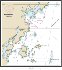
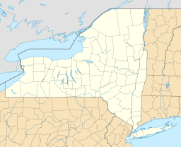
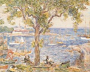
Echo Bay is a beautiful bay located in New Rochelle, a city in Westchester County, New York. It's part of the larger Long Island Sound. This bay is a popular spot for small boats to anchor, especially during the summer months.
The water in the anchorage area is usually between 4 and 15 feet deep. Smaller boats can find a shallow cove on the northeast side of the harbor. This cove is located between Harrison Islands and a small, rocky island near Echo Island. Many boats also anchor near the entrance of Echo Bay, where the water is deeper, around 20 to 24 feet.
On the northwest side of Echo Bay, there's a special channel. It's 100 feet wide and 15 feet deep. This channel is marked with buoys to guide boats safely. It leads to the New Rochelle Municipal Marina, which is at a place called Beaufort Point (also known as Hudson Park).
Contents
Exploring Echo Bay's Coastline
The area around Echo Bay has some interesting natural features.
Points and Rocks
Premium Point is a piece of land on the northeast side of the bay's entrance. Near Premium Point, there's a rock called "Spindle Rock." It gets covered by water when the tide is high. A red buoy marks its southwest end to warn boats.
Another rock, "Table Rock," can be seen when the tide is halfway out. It's part of a reef that stretches from the shore. "Hicks Ledge" is a small rocky area with 8 feet of water over it. It's about half a mile southwest of Premium Point.
The passage between "Spindle Rock" and Premium Point is quite rocky. Many rocks there are hidden even when the tide is low. On the southwest side of the bay's entrance, near Davenport Neck, you'll find "Baileys Rock." It's at the end of a reef that extends about 200 yards from the land. A gas buoy marks its eastern side.
Islands in the Bay
Echo Bay is home to several islands. These include Harrison Island, Echo Island, Clifford Island, Tank Island, and the two Hassock islands, Big Hassock and Little Hassock.
Other Features
Southwest of Echo Bay, there's a stone pier. It protects a private boat landing. Pine Island is a privately owned island covered with bushes. Near Pine Island, there are two bare rocks. Further southwest, there's a long, bare ledge. Its southwest end is marked by a special pole with a cage on top.
Between this pole and two other poles to the south, there's a channel. Small boats use this channel to travel between Echo Bay and New Rochelle Harbor.
Echo Bay's History
Echo Bay has a long and interesting history, dating back hundreds of years.
Early Days
In 1690, a man named Jean Machet bought land that is now the New Rochelle Municipal Marina. He wanted to build ships and trade with places like the West Indies. He also owned Echo Bay Island. In 1694, he sold the land to Joshua Ferris. Ferris was a "Tory," meaning he supported the British during the American Revolutionary War. He renamed the area Ferris Creek.
Joshua Ferris opened a tavern on his property. It became a popular spot, even for a group of outlaws called the "Skinners," led by Shubel Merritt. After the Revolutionary War, Shubel Merritt was killed at a tavern nearby. It's also said that Enoch Crosby, a famous spy for General Washington, started his spying career at Ferris's Tavern.
Mills and the Underground Railroad
In 1827, David Harrison bought the land. He built a dock to try and make it a busy landing spot again. A place called Snuff Mill Creek, near Sutton Manor, had a mill built in the early 1700s. It was first a grist mill, grinding grain, and later became a snuff mill.
Over the years, the mill was owned by several Quakers. One of them was believed to be active in helping enslaved people find freedom. It's thought that the mill was used as a stop on the Underground Railroad, a secret network that helped enslaved people escape to freedom. This area later became home to the New Rochelle Coal and Lumber Company.
Modern Marina
In 1945, the City of New Rochelle bought the land to create the Municipal Marina. They made many big improvements. They built a boathouse and strong walls along the water. They also smoothed and paved the dock area.
They also deepened Ferris Creek and built new piers and slips for small boats. This helped New Rochelle become a major boating center. In the 1960s, the city invested $2.3 million to make the marina even better. Today, the 5.3-acre Municipal Marina is one of the largest on Long Island Sound. It has space for 100 boats to anchor and 500 places for boats to dock. About 55 of these can hold boats longer than 30 feet.


