Egmere medieval settlement facts for kids
Quick facts for kids Egmere medieval settlement |
|
|---|---|

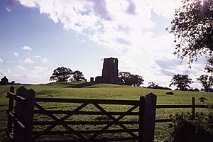
Looking south from the present road towards the ruins of St Edmund's Church
|
|
| Location | Norfolk |
| OS grid reference | TF 895 377 |
| Designated | 12 April 1976 |
| Reference no. | 1018173 |
| Lua error in Module:Location_map at line 420: attempt to index field 'wikibase' (a nil value). | |
Egmere medieval settlement is a deserted medieval village in Norfolk, England. It is located about 2.5 miles (4 km) west of Walsingham. Today, it is a Scheduled Monument. This means it is an important historical site protected by law.
Contents
What is a Deserted Medieval Village?
A deserted medieval village (often called a DMV) is a place where people used to live during the Middle Ages. But for some reason, everyone left. Now, only the remains of their homes and farms can be seen. These remains are usually just bumps and hollows in the ground. They show where buildings once stood.
History of Egmere
Early Records
Egmere was first written about in the Domesday Book of 1086. This was a huge survey ordered by William the Conqueror. It recorded who owned land and what was on it across England. The Domesday Book showed that the Bishop of Thetford owned the manor of Egmere. A manor was a large estate with a village and farms.
Population Changes
Records from tax lists, called subsidy rolls, show how the number of people living in Egmere changed. In 1334, there were 31 taxpayers in Egmere and a nearby place called Quarles. This means there were at least 31 households paying taxes. By 1449, this number dropped to just 10 taxpayers. In 1523, there were only 5. This shows a big decline in the village's population.
The Church and the King
In 1538, a big change happened in England. King Henry VIII closed down many monasteries. This event is known as the Dissolution of the Monasteries. After this, the King gave the manor of Egmere to Sir James Boleyn. By 1603, a report said that only one family lived in Egmere. The village church, St Edmund's, had even been turned into a barn.
The Church Building
The church of St Edmund was built in the 12th century. Its tall tower was added later, in the early 14th century. Today, the church is a ruin. It is also a Grade II* listed building. This means it is a very important historical building.
Egmere Today
Egmere used to be its own local area, called a civil parish, until 1935. Now, it is part of the larger area of Walsingham.
What Can You See Today?
The remains of the old village are on both sides of a small road. This road connects the villages of North Creake and South Creake to Walsingham. These remains are mostly "earthworks." Earthworks are changes in the shape of the land. They show where old buildings and features used to be.
South of the Road
South of the road, you can see the ruins of St Edmund's Church. The church and its churchyard are on a small hill. This hill is about 3 meters (10 feet) higher than the land around it. The church tower is still almost its original height. Parts of the church walls also remain.
About 125 meters (410 feet) south-south-east of the church was the site of the old manor house. Today, two cottages stand there. South of these cottages, you can see the earthwork remains of a fancy garden. There is a long, rectangular pond, about 100 meters (328 feet) long, at the southern edge of this garden.
West of the church and manor house, along a stream, are flat, rectangular areas. These are the sites where village buildings once stood.
North of the Road
North of the modern road, you can find the remains of fishponds. These were ponds where villagers would raise fish for food. There are also channels in the ground. These channels were likely part of a system to control the water flow to and from the ponds.
The Village Street
The main street of the old village can still be seen as a ditch. It runs south along the east side of the area north of the modern road. South of the modern road, it curves to the south-west. It passes right next to the north side of the church.
 | Laphonza Butler |
 | Daisy Bates |
 | Elizabeth Piper Ensley |

