El Campo de Peñaranda facts for kids
Quick facts for kids
El Campo de Peñaranda
|
|
|---|---|

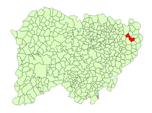
Location in Salamanca
|
|
| Country | Spain |
| Autonomous community | Castile and León |
| Province | Salamanca |
| Comarca | Tierra de Peñaranda |
| Area | |
| • Total | 45.2 km2 (17.5 sq mi) |
| Elevation | 839 m (2,753 ft) |
| Population
(2018)
|
|
| • Total | 266 |
| • Density | 5.885/km2 (15.24/sq mi) |
| Time zone | UTC+1 (CET) |
| • Summer (DST) | UTC+2 (CEST) |
| Postal code |
37317
|
El Campo de Peñaranda is a small village and municipality in western Spain. It is part of the Salamanca province and the Castile and León region. This area is known for its beautiful landscapes and rich history.
El Campo de Peñaranda is located about 40 kilometers (25 miles) from Salamanca, which is the main city of the province. In 2018, about 266 people lived there, making it a quiet and peaceful place.
Geography of El Campo de Peñaranda
El Campo de Peñaranda is a municipality, which is like a local government area. It covers about 45 square kilometers (17 square miles). This is roughly the size of 4,500 football fields!
The village sits 839 meters (2,753 feet) above sea level. This means it's quite high up, which can affect the weather and the types of plants that grow there. The postal code for the area is 37317.
Economy and Daily Life
The main way people earn a living in El Campo de Peñaranda is through agriculture. This means they grow crops and raise animals.
Farmers in this region often grow cereals like wheat and barley. They might also have livestock such as sheep or cattle. Agriculture has been important here for a very long time, shaping the local way of life.
See also
 In Spanish: El Campo de Peñaranda para niños
 | Emma Amos |
 | Edward Mitchell Bannister |
 | Larry D. Alexander |
 | Ernie Barnes |


