El Cerro facts for kids
Quick facts for kids
El Cerro
|
||
|---|---|---|
|
||

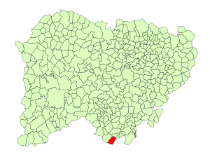
Location in Salamanca
|
||
| Country | Spain | |
| Autonomous community | Castile and León | |
| Province | Salamanca | |
| Comarca | Sierra de Béjar | |
| Area | ||
| • Total | 25.86 km2 (9.98 sq mi) | |
| Elevation | 955 m (3,133 ft) | |
| Population
(2018)
|
||
| • Total | 409 | |
| • Density | 15.816/km2 (40.96/sq mi) | |
| Time zone | UTC+1 (CET) | |
| • Summer (DST) | UTC+2 (CEST) | |
| Postal code |
37726
|
|
El Cerro is a small village and municipality in western Spain. It is located in the province of Salamanca. This area is part of the Castile and León region, which is one of Spain's autonomous communities.
El Cerro is about 89 kilometers (55 miles) away from the city of Salamanca, which is the capital of the province. In 2018, about 409 people lived in El Cerro.
Where is El Cerro Located?
The municipality of El Cerro covers an area of about 25.86 square kilometers (10 square miles). This is roughly the size of a small town.
The village sits high up, about 955 meters (3,133 feet) above sea level. This means it's located in a hilly or mountainous area. The postal code for El Cerro is 37726.
What is El Cerro's Economy Like?
The main way people in El Cerro make a living is through agriculture. This means they likely grow crops or raise animals. Agriculture is the foundation of the local economy.
Who Leads El Cerro?
Like any municipality, El Cerro has a leader. The current mayor is Juan Carlos Garavís González. He is part of the PSOE political party. The mayor helps manage the village and makes decisions for the community.
See also
 In Spanish: El Cerro (Salamanca) para niños


