Elbe-Elster facts for kids
Quick facts for kids
Elbe-Elster
|
|||
|---|---|---|---|
|
|||
 |
|||
| Country | |||
| State | Brandenburg | ||
| Capital | Herzberg | ||
| Area | |||
| • Total | 1,889.4 km2 (729.5 sq mi) | ||
| Population
(2001)
|
|||
| • Total | 131,161 | ||
| • Density | 69.4194/km2 (179.795/sq mi) | ||
| Time zone | UTC+1 (CET) | ||
| • Summer (DST) | UTC+2 (CEST) | ||
| Vehicle registration | EE | ||
| Website | landkreis-elbe-elster.de | ||
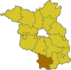
Elbe-Elster is a Kreis (district) in the southern part of Brandenburg, Germany. It's named after two important rivers, the Elbe and the Black Elster. The main town, or capital, of the district is Herzberg.
Contents
History of Elbe-Elster District
How the District Was Formed
The Elbe-Elster district was created in 1993. Before that, this area was made up of three smaller districts. These were called Finsterwalde, Bad Liebenwerda, and Herzberg. They all joined together to form the larger district we know today.
Geography of Elbe-Elster
Rivers and Natural Areas
This district gets its name from two important rivers. The mighty Elbe river forms its western border. This border is shared with another German state called Saxony. The other river is the Schwarze Elster, which means "Black Elster." It's a smaller river that flows through the district and eventually joins the Elbe.
The district is also part of a larger area called Lusatia. Along the Black Elster river, there are special wet areas called fens. These fens are home to many cool and rare animals. You might find colorful kingfishers, busy beavers, and playful otters living there.
Understanding the Elbe-Elster Coat of Arms
Symbols and Their Meanings
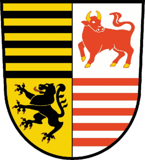
Every district has a special symbol called a coat of arms. The Elbe-Elster district got its coat of arms in 1995. It tells a story about the area's past.
Let's look at what the symbols mean:
- The lion in the bottom left part of the shield comes from the old county of Meißen. This county used to control the southern part of the district a long time ago.
- The black bars stand for the Saxony-Wittenberg county. The area around Bad Liebenwerda was once part of this county.
- The red bars are from the oldest coat of arms of Brandenburg. This shows the district's connection to the state it's in.
- The bull is a special symbol for the Lower Lusatia area. This is the larger region where the Elbe-Elster district is located.
Towns and Villages in Elbe-Elster
Exploring Local Communities
The Elbe-Elster district is home to many different towns and smaller communities. Some of the larger towns, like Bad Liebenwerda, Finsterwalde, and Herzberg (Elster), manage themselves. Other smaller villages group together to share services.
Here are some of the towns and municipalities you can find in the district:
- Bad Liebenwerda
- Doberlug-Kirchhain
- Elsterwerda
- Falkenberg/Elster
- Finsterwalde
- Herzberg (Elster)
- Mühlberg
- Schönewalde
- Sonnewalde
- Uebigau-Wahrenbrück
- Röderland (a municipality that manages itself)
Many smaller villages are part of groups called Ämter. These groups work together on things like local government. Some examples of these groups include Elsterland, Kleine Elster (Niederlausitz), Plessa, Schlieben, and Schradenland.
See also
 In Spanish: Distrito de Elbe-Elster para niños
 | Precious Adams |
 | Lauren Anderson |
 | Janet Collins |


