Ellenton, Georgia facts for kids
Quick facts for kids
Ellenton, Georgia
|
|
|---|---|

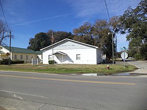
Ellenton City Hall
|
|

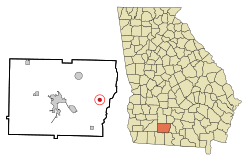
Location in Colquitt County and the state of Georgia
|
|
| Country | United States |
| State | Georgia |
| County | Colquitt |
| Area | |
| • Total | 0.80 sq mi (2.06 km2) |
| • Land | 0.79 sq mi (2.05 km2) |
| • Water | 0.00 sq mi (0.01 km2) |
| Elevation | 259 ft (79 m) |
| Population
(2020)
|
|
| • Total | 210 |
| • Density | 265.49/sq mi (102.50/km2) |
| Time zone | UTC-5 (Eastern (EST)) |
| • Summer (DST) | UTC-4 (EDT) |
| ZIP code |
31747
|
| Area code(s) | 229 |
| FIPS code | 13-27008 |
| GNIS feature ID | 0331648 |
| Website | http://www.ellentonga.com/ |
Ellenton is a small town in Colquitt County, Georgia, United States. It became an official town in 1970. This happened when the Georgia General Assembly approved its incorporation.
Ellenton is located at 31°10′36″N 83°35′17″W / 31.17667°N 83.58806°W. It covers an area of about 0.8 square miles (2.06 square kilometers). All of this area is land.
Population and People
A census is an official count of how many people live in a place. It also gathers information about them. According to the 2020 census, Ellenton had a population of 210 people. This number was 281 in the 2010 census.
Here is how Ellenton's population has changed over the years:
| Historical population | |||
|---|---|---|---|
| Census | Pop. | %± | |
| 1930 | 297 | — | |
| 1940 | 427 | 43.8% | |
| 1950 | 429 | 0.5% | |
| 1960 | 385 | −10.3% | |
| 1970 | 337 | −12.5% | |
| 1980 | 277 | −17.8% | |
| 1990 | 227 | −18.1% | |
| 2000 | 336 | 48.0% | |
| 2010 | 281 | −16.4% | |
| 2020 | 210 | −25.3% | |
| U.S. Decennial Census 1850-1870 1870-1880 1890-1910 1920-1930 1940 1950 1960 1970 1980 1990 2000 2010 |
|||
In the year 2000, there were 336 people living in Ellenton. These people lived in 109 households, and 81 of those were families.
See also
 In Spanish: Ellenton (Georgia) para niños
 | DeHart Hubbard |
 | Wilma Rudolph |
 | Jesse Owens |
 | Jackie Joyner-Kersee |
 | Major Taylor |

