Elora, Tennessee facts for kids
Quick facts for kids
Elora, Tennessee
|
|
|---|---|

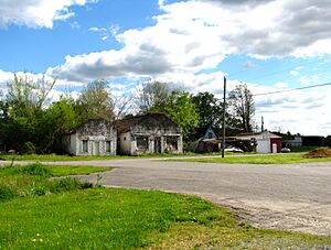
Buildings along Green Road (2016)
|
|
| Country | United States |
| State | Tennessee |
| County | Lincoln |
| Elevation | 929 ft (283 m) |
| Time zone | UTC-6 (CST) |
| • Summer (DST) | UTC-5 (CDT) |
| ZIP Code |
37328
|
| Area code | 931 |
| FIPS code | 47-23800 |
| GNIS ID | 1283729 |
Elora is a small, unincorporated community in Lincoln County, Tennessee, United States. This means it's a group of homes and businesses that isn't officially a city or town with its own local government. Elora is located about 16 miles (26 km) southeast of Fayetteville. It's also very close to the Alabama state line, only about 2 miles (3.2 km) north of it.
Elora's Past
Long ago, Elora had a different name: Baxter Station. It became a stop along the Fayetteville and Decherd Branch Railroad in the 1850s. This railroad helped people and goods travel through the area. Today, Elora still has its own post office, and its special code for mail is 37328.
Where is Elora?
Elora is mainly found where two roads meet: Tennessee State Route 121 and Tennessee State Route 122. Route 122 is also known as the John Hunter Highway.
- Route 121 connects Elora to U.S. Route 64 and the Tims Ford Lake area to the north. It also goes southwest towards Madison County, Alabama.
- Route 122 links Elora with Huntland to the east. These roads help people travel in and out of the community.
People Who Grew Up in Elora
Even though Elora is a small community, some notable people were born there.
- George C. Hawkins (born in Elora in 1918) was an important person in Alabama's government. He served in both parts of the Alabama State Legislature (the House from 1951 to 1959 and the Senate from 1963 to 1967). He was also a lawyer in Gadsden.
- Bill Hefner was born in Elora. He later became a member of the United States House of Representatives for North Carolina. This means he helped make laws for the country as part of the U.S. Congress.
 | Mary Eliza Mahoney |
 | Susie King Taylor |
 | Ida Gray |
 | Eliza Ann Grier |


