Elysian, Minnesota facts for kids
Quick facts for kids
Elysian, Minnesota
|
|
|---|---|

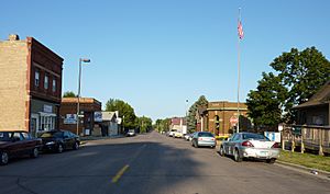
Downtown Elysian
|
|

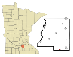
Location Elysian
|
|
| Country | United States |
| State | Minnesota |
| Counties | Le Sueur, Waseca |
| Government | |
| • Type | Mayor – Council |
| Area | |
| • Total | 1.44 sq mi (3.73 km2) |
| • Land | 1.18 sq mi (3.05 km2) |
| • Water | 0.26 sq mi (0.68 km2) |
| Elevation | 1,027 ft (313 m) |
| Population
(2020)
|
|
| • Total | 708 |
| • Density | 601.02/sq mi (231.97/km2) |
| Time zone | UTC-6 (Central (CST)) |
| • Summer (DST) | UTC-5 (CDT) |
| ZIP code |
56028
|
| Area code(s) | 507 |
| FIPS code | 27-19160 |
| GNIS feature ID | 2394684 |
Elysian (/ɛˈliːzjən/ el-EE-zyən) is a small city in the U.S. state of Minnesota. It is located in both Le Sueur and Waseca counties. According to the 2020 Census, 708 people lived in Elysian. It is different from Elysian Township, which is a nearby area.
Contents
History of Elysian
Elysian was first planned out in 1856. When a town is "platted," it means its streets and lots are officially mapped. The city was named after Elysium from ancient Greek stories. Elysium was a place where heroes went after they died. Elysian officially became a city in 1884.
Geography and Location
Elysian is located about 70 miles south-southwest of Minneapolis, a much larger city in Minnesota. This means it's mostly south but also a bit to the west of Minneapolis.
Highways and Land Area
Minnesota Highway 60 is an important road that runs through the community. The city covers a total area of about 1.44 square miles (3.73 square kilometers). Most of this area, about 1.18 square miles (3.05 square kilometers), is land. The rest, about 0.26 square miles (0.68 square kilometers), is water.
Population and People

The population of Elysian has changed over the years. Here's how many people lived there during different census years:
| Historical population | |||
|---|---|---|---|
| Census | Pop. | %± | |
| 1880 | 167 | — | |
| 1890 | 348 | 108.4% | |
| 1900 | 459 | 31.9% | |
| 1910 | 345 | −24.8% | |
| 1920 | 354 | 2.6% | |
| 1930 | 388 | 9.6% | |
| 1940 | 382 | −1.5% | |
| 1950 | 402 | 5.2% | |
| 1960 | 382 | −5.0% | |
| 1970 | 445 | 16.5% | |
| 1980 | 454 | 2.0% | |
| 1990 | 445 | −2.0% | |
| 2000 | 486 | 9.2% | |
| 2010 | 652 | 34.2% | |
| 2020 | 708 | 8.6% | |
| U.S. Decennial Census | |||
Population in 2020
In 2020, there were 708 people living in Elysian. Most of the people were White, making up about 92.93% of the population. Other groups included African American, American Native, and Asian residents. About 4.51% of the people were from two or more races. A small number, 0.42%, were Hispanic or Latino.
The average age of people in Elysian in 2020 was 52.8 years. About 12.2% of the residents were under 18 years old.
Population in 2010
In 2010, the city's population was 652 people. The racial makeup was similar to 2020, with most residents being White (96.6%). The average age in 2010 was 43.4 years. About 23.6% of the residents were under 18 years old.
Education
Public schools in Elysian are part of the Waterville-Elysian-Morristown School District. This district helps provide education for students in the area.
See also
 In Spanish: Elysian (Minnesota) para niños
 | Dorothy Vaughan |
 | Charles Henry Turner |
 | Hildrus Poindexter |
 | Henry Cecil McBay |

