Embarras River (Alberta) facts for kids
Quick facts for kids Embarras River |
|
|---|---|

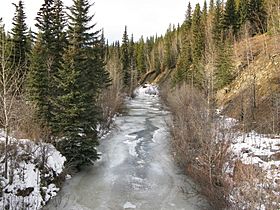
The Embarras River south of Hinton, Alberta
|
|
| Country | Canada |
| Province | Alberta |
| Physical characteristics | |
| Main source | Embarras River Headwaters 1,189 m (3,901 ft) 53°10′39″N 117°00′27″W / 53.17750°N 117.00750°W |
| River mouth | McLeod River 927 m (3,041 ft) 52°27′37″N 116°37′06″W / 52.46028°N 116.61833°W |
The Embarras River is a short river located in west-central Alberta, Canada. It flows through the beautiful foothills of the Canadian Rockies. The river's name comes from a French word meaning "obstruction." This is because the river often has lots of driftwood that can block its path.
Contents
River's Journey: Where the Embarras River Flows
The Embarras River starts near Robb, Alberta. It forms where a few small creeks join together. From there, it flows generally north and northeast.
Path Through the Foothills
The river winds its way through the lower hills of the Canadian Rockies. These foothills are just east of Jasper National Park. The Embarras River flows alongside Alberta Highway 47 for some distance.
Joining Other Rivers
Eventually, the Embarras River meets and joins the Erith River. After this, it flows into the McLeod River. The McLeod River then flows into the larger Athabasca River.
Seasonal Changes
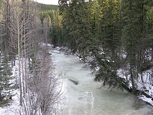
During the cold winter months, the Embarras River freezes solid. In the summer, when the ice melts, the river flows quickly.
Embarras Landing: A Former Coal Town
Embarras Landing was once a small town. It was a coal mining community built where the Embarras River meets Prest Creek.
Tributaries: Creeks Joining the River
A tributary is a smaller stream or river that flows into a larger one. The Embarras River has several creeks that join it along its journey. These include:
- Dummy (Hay) Creek
- Prest Creek
- Neill Creek
- Mitchell Creek
- Baril Creek
- Lambert Creek
 | DeHart Hubbard |
 | Wilma Rudolph |
 | Jesse Owens |
 | Jackie Joyner-Kersee |
 | Major Taylor |


