Emerson, Georgia facts for kids
Quick facts for kids
Emerson, Georgia
|
|||
|---|---|---|---|

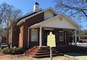
Emerson City Hall
|
|||
|
|||

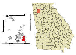
Location in Bartow County and the state of Georgia
|
|||
| Country | United States | ||
| State | Georgia | ||
| County | Bartow | ||
| Incorporated (city) | January 1, 1889 | ||
| Area | |||
| • Total | 8.63 sq mi (22.36 km2) | ||
| • Land | 8.63 sq mi (22.36 km2) | ||
| • Water | 0.00 sq mi (0.01 km2) | ||
| Elevation | 833 ft (254 m) | ||
| Population
(2020)
|
|||
| • Total | 1,415 | ||
| • Density | 163.94/sq mi (63.30/km2) | ||
| Time zone | UTC-5 (Eastern (EST)) | ||
| • Summer (DST) | UTC-4 (EDT) | ||
| ZIP code |
30137
|
||
| Area code(s) | 770/678/470/943 | ||
| FIPS code | 13-27344 | ||
| GNIS feature ID | 0331660 | ||
Emerson is a small city located in the southern part of Bartow County, Georgia, in the United States. It's easy to reach because it's close to major roads like US-41 and I-75.
In 2010, about 1,470 people lived in Emerson. This was a big jump from the year 2000, when the population was 1,092. Emerson is also known as a main entrance to Red Top Mountain State Park, a fun place surrounded by Lake Allatoona.
Contents
History of Emerson
When was Emerson founded?
Emerson officially became a city in 1889. This means it was given the legal right to govern itself. The city was named after Joseph E. Brown, who was the 42nd Governor of Georgia. He was an important leader in the state's history.
Geography of Emerson
Where is Emerson located?
Emerson is located in Georgia at specific coordinates: 34.131185 degrees North latitude and -84.752867 degrees West longitude. These numbers help pinpoint its exact spot on a map.
How big is Emerson?
The city of Emerson covers a total area of about 18.95 square kilometers (or 7.32 square miles). Most of this area is land, about 18.91 square kilometers (7.30 square miles). A very small part, about 0.04 square kilometers (0.015 square miles), is water.
People of Emerson
How many people live in Emerson?
Every ten years, the United States counts its population in what's called a census. This helps us understand how many people live in different areas. Here's how Emerson's population has changed over the years:
| Historical population | |||
|---|---|---|---|
| Census | Pop. | %± | |
| 1880 | 200 | — | |
| 1890 | 437 | 118.5% | |
| 1900 | 581 | 33.0% | |
| 1910 | 659 | 13.4% | |
| 1920 | 632 | −4.1% | |
| 1930 | 657 | 4.0% | |
| 1940 | 1,497 | 127.9% | |
| 1950 | 1,527 | 2.0% | |
| 1960 | 1,320 | −13.6% | |
| 1970 | 1,326 | 0.5% | |
| 1980 | 1,507 | 13.7% | |
| 1990 | 1,178 | −21.8% | |
| 2000 | 1,092 | −7.3% | |
| 2010 | 1,470 | 34.6% | |
| 2020 | 1,415 | −3.7% | |
| U.S. Decennial Census | |||
What is the population like in 2020?
The most recent count was in 2020. At that time, 1,415 people lived in Emerson. These people made up 629 households, with 469 of them being families.
The census also looks at the different backgrounds of people living in the city. This helps show how diverse a community is.
| Race | Num. | Perc. |
|---|---|---|
| White (non-Hispanic) | 1,022 | 72.23% |
| Black or African American (non-Hispanic) | 98 | 6.93% |
| Native American | 8 | 0.57% |
| Asian | 20 | 1.41% |
| Pacific Islander | 1 | 0.07% |
| Other/Mixed | 62 | 4.38% |
| Hispanic or Latino | 204 | 14.42% |
Emerson in Movies and TV
Emerson has been a popular spot for filming movies and TV shows! You might have seen parts of the city without even knowing it.
For example, the TV mini-series Manhunt: Unabomber was filmed there. Also, some scenes from the movie The 5th Wave were shot in Emerson. If you're a fan of the Fast & Furious movies, you might recognize Old Alabama Road in Emerson, as it has appeared in several of those films.
Schools in Emerson
Emerson has schools for students of different ages. These schools help educate the children and teens living in the city and nearby areas.
- Emerson Elementary School
- Red Top Middle School
- Excel Christian Academy
See also
 In Spanish: Emerson (Georgia) para niños


