
Empire Tract facts for kids

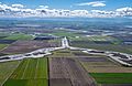
USGS aerial imagery of the Empire Tract
|
|

Empire Tract
Location in Sacramento-San Joaquin River Delta

Empire Tract
Location in California

Empire Tract
Location in the United States
|
|
| Geography | |
|---|---|
| Location | Northern California |
| Coordinates | 38°03′55″N 121°28′48″W / 38.06528°N 121.48000°W |
| Adjacent bodies of water | Sacramento–San Joaquin River Delta |
| Highest elevation | -10 ft (-3.05 m) |
| Administration | |
|
United States
|
|
| State | |
| County | San Joaquin |
The Empire Tract is a special kind of island located in the Sacramento–San Joaquin River Delta in California. It's not a natural island formed by volcanoes or rivers, but rather a piece of land that has been protected by walls called levees. These levees keep the water out, allowing people to use the land for farming and other activities.
Empire Tract is part of San Joaquin County. It is managed by a group called Reclamation District 2029. This district helps make sure the levees are strong and that the land stays safe from floods.
What is Empire Tract?
Empire Tract is a low-lying area of land. It's so low that its elevation was measured as −10 ft (−3.0 m) in 1981 by the United States Geological Survey. This means parts of the island are actually below sea level! Imagine standing on land that is lower than the ocean. That's why the levees are so important here.
Location and Geography
The island is found in the large water network known as the Sacramento–San Joaquin River Delta. This delta is a huge area where the Sacramento and San Joaquin rivers meet before flowing into San Francisco Bay. It's a mix of rivers, channels, and islands like Empire Tract. The exact location of Empire Tract can be found using its coordinates: 38°03′55″N 121°28′48″W / 38.06528°N 121.48000°W.
How Levees Protect the Land
Because Empire Tract is below sea level, it needs constant protection from the surrounding water. This protection comes from the levees. Levees are like tall, strong walls made of earth. They are built around the edges of the island to hold back the river water. Without these levees, the land would be flooded, making it impossible to live or farm there.
The Reclamation District 2029 is responsible for taking care of these levees. They make sure the levees are repaired when needed and that they are strong enough to protect the land, especially during heavy rains or high tides.
Images for kids
-
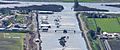
A 2019 aerial photo of White Slough taken looking south from the Terminous Tract; King Island is on the left and the Empire Tract is on the right.
-

Herbert Hoover (right) with son Allan (left)
-
The Eight Mile Road bridge, constructed in 1936 across the Honker Cut

.jpg)
.JPG)
