Entrance Island (British Columbia) facts for kids
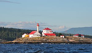
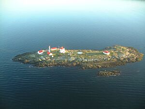
Entrance Island is a small, rocky piece of land in the Strait of Georgia. It is about 841 meters (2,759 feet) north of Gabriola Island. Many marine animals use this island. For example, harbour seals and Steller's sea lions often rest there. This resting place is called a "haul-out." It's where they come out of the water to relax and warm up.
Entrance Island Lighthouse: A Guiding Light
 |
|
| Entrance Island Light off Gabriola Island, Georgia Strait, British Columbia | |
| Location | Gabriola Island Strait of Georgia British Columbia Canada |
|---|---|
| Coordinates | 49°12′33″N 123°48′29″W / 49.209214°N 123.808105°W |
| Year first constructed | 1986 (first) |
| Year first lit | 1970 (current) |
| Construction | concrete tower (current) wooden tower (first) |
| Tower shape | cylindrical tower with balcony and lantern (current) square tower |
| Markings / pattern | white tower, red balcony and lantern |
| Height | 14 metres (46 ft) |
| Focal height | 19 metres (62 ft) |
| Characteristic | Fl W 5s. |
| Admiralty number | G5488 |
| CHS number | CCG 0435 |
| NGA number | 13300 |
| ARLHS number | CAN-171 |
The Entrance Island Lighthouse is a special kind of lighthouse. It is a "manned light station," which means people live and work there. The lighthouse was first built in 1875. Its main job is to help guide ships safely into Nanaimo harbour. This harbour is a busy port on Vancouver Island.
The lighthouse is easy to spot from the ferry that travels between Horseshoe Bay and Departure Bay. Another ferry, which goes from Tsawwassen to Duke Point, also passes very close to it. The current lighthouse tower is 14 meters (46 feet) tall. Its light shines from 19 meters (62 feet) above the water. Today, the light is powered by solar energy.
Oceanographic Research at the Lighthouse
The Entrance Island Lighthouse is not just for guiding ships. It is also a key spot for science. It is one of 12 lighthouses that are part of the British Columbia Shore Station Oceanographic Program. Since 1936, scientists have been collecting important information here. Every day, they measure the temperature and saltiness of the coastal water.
This long-term data helps us understand changes in the ocean. For example, the information from Entrance Island shows that coastal water temperatures have gone up. They have increased by 0.15 degrees Celsius (0.27 degrees Fahrenheit) every ten years. This warming trend is a result of climate change, which is largely caused by human activities.
 | William L. Dawson |
 | W. E. B. Du Bois |
 | Harry Belafonte |


