Erbusaig Bay facts for kids
Quick facts for kids Erbusaig Bay |
|
|---|---|

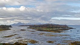
A view towards the Cuillin Mountains on Skye from the Kyle-bound train as it passes beside Erbusaig Bay.
|
|
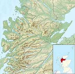
| Location | Lochalsh peninsula, Scotland |
| Coordinates | 57°18′7.560″N 5°43′26.700″W / 57.30210000°N 5.72408333°W |
| River sources | Erbusaig Burn |
| Ocean/sea sources | Inner Sound |
| Basin countries | Scotland |
| Max. length | 7.4 km (4.6 mi) |
| Max. width | 8.85 km (5.50 mi) |
| Islands | Black Islands |
| Settlements | Erbusaig |
Erbusaig Bay is a quiet bay found on the west coast of Scotland. It's located in the Scottish Highlands, on the Lochalsh peninsula. The small village of Erbusaig sits right on the western side of the bay.
Exploring Erbusaig Bay
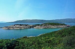
Erbusaig Bay has a classic half-circle shape. It faces the island of Scalpay. Inside the bay, you'll find the small twin Black Islands. These islands are in the northern part of the bay.
The land around the bay has two huge, flat rock hills. These hills are like natural platforms. The southern hill is taller, reaching about 215 feet high. The northern hill is a bit lower. Both hills have some heather and bracken plants, but you can see bare rock too.
The village of Erbusaig is at the very end of the bay. It sits in a V-shaped flat area. This area was carved out of the rock by the Erbusaig Burn, a small stream. The village is a few feet higher than the bay itself. You can see many white houses scattered across this flat area.
The west coast of Scotland near Erbusaig Bay has many small islands. Erbusaig Bay itself has about two dozen tiny islands. The biggest ones are the Black Islands.
Getting to Erbusaig Bay
Erbusaig is the main village at the head of the bay. The main railway line along the west coast passes by the bay. It follows the curved shape of the bay as it goes.
To the south, you'll find the opening to Kyle of Lochalsh. This leads into a sea loch called Loch Alsh. Further southwest is the northern shore of the Isle of Skye. Here you can find Broadford Bay and the village of Broadford. Directly south is Kyle Rhea, a narrow channel that separates the mainland from the Isle of Skye.
You can reach Erbusaig Bay by train or by road. The A87 road runs west from Invergarry. It goes along the north shores of Loch Garry and Loch Cluanie. Then it travels through Glen Shiel and along Loch Duich to Kyle of Lochalsh. From there, it crosses the Skye Bridge to places like Kyleakin, Broadford, and Portree. The road ends at Uig on the west coast of the Isle of Skye. A smaller road leaves the A87 at Kyle of Lochalsh and goes north, passing by Erbusaig Bay.
 | Claudette Colvin |
 | Myrlie Evers-Williams |
 | Alberta Odell Jones |


