Loch Garry facts for kids
Quick facts for kids Loch Garry |
|
|---|---|

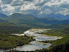
Looking west from the lookout on the A87
|
|
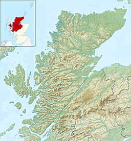
| Location | Scotland |
| Coordinates | 57°05′N 4°55′W / 57.083°N 4.917°W |
| Primary inflows | River Garry |
| Basin countries | United Kingdom |
| Max. length | 4 km (2.5 mi) |
| Max. width | 0.25 km (0.16 mi) |
| Surface area | 686 ha (1,700 acres) |
| Average depth | 11.25 ft (3.43 m) |
| Max. depth | 50 ft (15 m) |
| Water volume | 846,000,000 cu ft (24,000,000 m3) |
| Shore length1 | 30.7 km (19.1 mi) |
| Surface elevation | 83 m (272 ft) |
| Max. temperature | 57 °F (14 °C) |
| Min. temperature | 46 °F (8 °C) |
| Islands | 7 |
| 1 Shore length is not a well-defined measure. | |
Loch Garry is a beautiful freshwater Loch (which is the Scottish word for a lake). It is found in Lochaber, Scotland. The loch is about 25 km (15 miles) north of Fort William.
Loch Garry is famous for how it looks from the A87 road. If you look at it from a certain angle, it appears shaped like a map of Scotland! Many people take photos of it because of this cool trick of perspective.
About Loch Garry
Loch Garry is a long, narrow lake. It stretches for about 8 km (5 miles). Its deepest point is around 67 meters (220 feet). This makes it quite deep!
The loch gets its water from Loch Quoich, which is about 10 km (6 miles) upstream. The water flows into Loch Garry through the River Garry. From Loch Garry, the water then drains into Loch Oich. Loch Oich is part of the famous Great Glen.
Hydroelectric Power
Both Loch Garry and Loch Quoich are used to make hydro-electric power. This means they use the power of moving water to create electricity. A large dam was built on Loch Quoich. It is the biggest rockfill dam in Scotland.
Water from the lochs travels through tunnels to two power stations. Each station can produce 20 megawatts of electricity. This power scheme was finished in 1962. It helps provide clean energy for homes and businesses.
History and People
The area around Loch Garry used to be home to the Clan MacDonell of Glengarry. A clan is a group of families with a common ancestor. However, during a time called the Highland Clearances, many people had to leave their homes. This meant the population in the glen became very small.
Today, only a few estates remain in the area. The main activities are deerstalking (hunting deer) and forestry (managing forests). There isn't much tourism, except for people who enjoy munro-bagging. Munro-bagging means climbing mountains in Scotland that are over 3,000 feet (914.4 meters) high. The mountains at the head of the glen are very remote and beautiful.
A quiet road runs along the north side of Loch Garry. It continues past Loch Quoich all the way to Kinlochhourn. From Kinlochhourn, you can find a footpath that leads to Knoydart. Knoydart is a very wild and remote part of Scotland.
Other Loch Garrys
It's interesting to know that there are two Loch Garrys in Scotland! The information you see in the box at the top of this page (like length, depth, and area) is actually for the other Loch Garry, which is in Perthshire.
The Loch Garry we are talking about here, in the Highland area, has different measurements. Its maximum depth is about 67 meters (220 feet). It is about 8 km (5 miles) long. If you include the part of the loch that was flooded by the hydroelectric dam, called Inchlaggan, it becomes about 10 km (6 miles) long.
There is also another Loch Garry in Glengarry County, Ontario, Canada. This Canadian loch was named by the Clan MacDonell of Glengarry. They named it after their original home loch in Scotland when they moved to Canada during the Highland Clearances.
 | Percy Lavon Julian |
 | Katherine Johnson |
 | George Washington Carver |
 | Annie Easley |


