
Erula facts for kids
Quick facts for kids
Erula
Èrula
|
|
|---|---|
| Comune di Erula | |
.jpg) |
|
| Country | Italy |
| Region | Sardinia |
| Province | Province of Sassari (SS) |
| Frazioni | Sa Mela, Tettile |
| Area | |
| • Total | 40.1 km2 (15.5 sq mi) |
| Elevation | 457 m (1,499 ft) |
| Population
(Dec. 2004)
|
|
| • Total | 807 |
| • Density | 20.12/km2 (52.12/sq mi) |
| Demonym(s) | Erulesi |
| Time zone | UTC+1 (CET) |
| • Summer (DST) | UTC+2 (CEST) |
| Postal code |
07030
|
| Dialing code | 079 |
Erula is a small town, also called a comune, located on the beautiful island of Sardinia in Italy. People who live in Erula are called Erulesi.
This town is part of the Province of Sassari. It's about 180 kilometers (112 miles) north of Cagliari. Cagliari is the capital city of Sardinia. Erula is also about 35 kilometers (22 miles) east of Sassari, another important city.
As of December 2004, Erula had a population of 807 people. The town covers an area of about 40.1 square kilometers (15.5 square miles).
Exploring Erula's Divisions
Erula is made up of smaller parts called frazioni. Think of these as small villages or hamlets that belong to the main town.
- Sa Mela
- Tettile
These frazioni are important parts of the Erula community.
Erula's Neighbors
Erula shares its borders with several other towns. These are like its neighbors on the map.
Knowing its neighbors helps us understand where Erula is located.
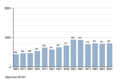
How Erula's Population Has Changed
This section shows how the number of people living in Erula has changed over many years. This is called demographic evolution.
The chart below uses data from ISTAT, which is the official source for statistics in Italy. It helps us see if Erula's population grew or shrank over time.
See also
 In Spanish: Erula para niños
