Etna, Licking County, Ohio facts for kids
Quick facts for kids
Etna, Ohio
|
|
|---|---|

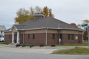
Township hall at Etna
|
|

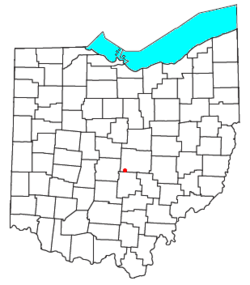
Location of Etna in Ohio
|
|
| Country | United States |
| State | Ohio |
| County | Licking |
| Township | Etna |
| Area | |
| • Total | 0.62 sq mi (1.60 km2) |
| • Land | 0.61 sq mi (1.59 km2) |
| • Water | 3.11 sq mi (0.01 km2) |
| Elevation | 1,070 ft (330 m) |
| Population
(2020)
|
|
| • Total | 1,209 |
| • Density | 1,965.85/sq mi (759.11/km2) |
| Time zone | UTC-5 (Eastern (EST)) |
| • Summer (DST) | UTC-4 (EDT) |
| ZIP Code |
43062 (Pataskala)
|
| FIPS code | 39-25676 |
| GNIS feature ID | 2633229 |
Etna is a small community in Licking County, Ohio, United States. It's not a city or town with its own government. Instead, it's called an "unincorporated community" and a "census-designated place" (CDP). This means it's a specific area that the government counts for population, but it's part of a larger township.
In 2020, about 1,209 people lived in Etna. It sits at an elevation of about 1,069 feet (326 meters) above sea level. You can find Etna where two important roads meet: U.S. Route 40 and Ohio State Route 310.
Contents
A Look Back: Etna's History
Etna wasn't always called Etna! When it was first created in 1832, its name was "Carthage". This happened when the National Road, a very important early highway, was being built through the area.
The community's name changed to Etna because it is located within Etna Township. A post office, where people could send and receive mail, has been operating in Etna since 1833.
Where is Etna Located?
Etna is in the southwestern part of Licking County. It's right in the middle of Etna Township.
Two major highways pass by Etna:
- U.S. Route 40 runs along the northern edge of the community.
- Interstate 70 forms the southern edge.
You can get to Etna from Interstate 70 by taking Exit 118, which is State Route 310. Both US 40 and I-70 can take you to bigger cities:
- Go west about 18 miles (29 km) to reach Columbus.
- Go east about 35 miles (56 km) to get to Zanesville.
Newark, which is the main city and county seat of Licking County, is about 20 miles (32 km) northeast of Etna.
Etna's Size and Water
The Etna census-designated place covers a total area of about 0.62 square miles (1.6 square kilometers). Most of this area is land. Only a very small part, about 0.01 square miles (0.03 square kilometers), is water.
The water in Etna flows northeast into the South Fork of the Licking River. The Licking River then flows east into the Muskingum River. The Muskingum River is part of the larger Ohio River watershed, which means its waters eventually join the Ohio River.
How Many People Live Here?
| Historical population | |||
|---|---|---|---|
| Census | Pop. | %± | |
| 2020 | 1,209 | — | |
| U.S. Decennial Census | |||
The population of Etna has been counted by the U.S. Census Bureau. In 2020, there were 1,209 people living in Etna.
See also
 In Spanish: Etna (Ohio) para niños
 | Stephanie Wilson |
 | Charles Bolden |
 | Ronald McNair |
 | Frederick D. Gregory |

