Eurelia facts for kids
Quick facts for kids EureliaSouth Australia |
|||||||||||||||
|---|---|---|---|---|---|---|---|---|---|---|---|---|---|---|---|

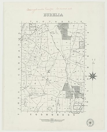
Hundred of Eurelia, 1889, which shows the proposed extent of the government town in the bottom right hand corner
|
|||||||||||||||
| Established | 12 September 1878 (town) 16 December 1999 (locality) |
||||||||||||||
| Postcode(s) | 5431 | ||||||||||||||
| Elevation | 525 m (1,722 ft)(railway station) | ||||||||||||||
| Time zone | ACST (UTC+9:30) | ||||||||||||||
| • Summer (DST) | ACDT (UTC+10:30) | ||||||||||||||
| Location |
|
||||||||||||||
| LGA(s) | District Council of Orroroo Carrieton | ||||||||||||||
| Region | Yorke and Mid North | ||||||||||||||
| County | Dalhousie | ||||||||||||||
| State electorate(s) | Stuart | ||||||||||||||
| Federal Division(s) | Grey | ||||||||||||||
|
|||||||||||||||
|
|||||||||||||||
| Footnotes | Locations Adjoining localities |
||||||||||||||
Eurelia is a small town and area in the Australian state of South Australia. It is located on the east side of the Flinders Ranges. Eurelia is about 264 kilometers north of Adelaide, the state capital. It is also about 20 kilometers from Orroroo, a nearby town.
What's in a Name?
The name Eurelia comes from the local Jadliaura language. It means "place of the ear." Some people believe this relates to old Dreamtime stories. These stories suggest that Eurelia is like an "ear" of a giant sleeping figure in the Flinders Ranges.
The town's name is pronounced in a way that has led to some funny jokes! People sometimes say it sounds like "you're a liar" or "you really are." The "correct" way to say it is "you really are."
History and Government
The town of Eurelia was officially planned in July 1878. It became a government town on September 12, 1878. Its name came from the larger area called the Hundred of Eurelia. The boundaries for the Eurelia locality (the wider area) were set on December 16, 1999.
For six years, from 1888 to 1894, the local government council was called the District Council of Eurelia. Today, Eurelia is part of the District Council of Orroroo Carrieton.
Eurelia is also part of larger government areas. It is in the federal division of Grey. For state elections, it is in the Stuart district.
Land Use
The land around Eurelia is mainly used for 'primary production'. This means people use the land for farming. They grow crops and raise animals on large properties.
Railways
Eurelia was once on the route of the old Peterborough–Quorn railway line. This railway was built in 1881. Regular trains stopped running on this line by the 1980s.
After that, Eurelia became the northern end of a special railway. The Steamtown Peterborough Railway Preservation Society ran trains from Peterborough to Eurelia. This happened between 1981 and 2002.
Water Dams
Eurelia had two important dams. The first dam was built when the railway was constructed in 1881. It could hold a lot of water.
Later, a second dam was built to help. Construction started in 1948 and finished in 1952. The idea was for the old dam to help clean the water before it went into the new one. Both dams filled up in 1958 after heavy rains.
When there were droughts, water from these dams was very important. It was shipped by train across the South Australian Railway system to other places that needed it.


