
Orroroo, South Australia facts for kids
Quick facts for kids OrrorooSouth Australia |
|||||||||||||||
|---|---|---|---|---|---|---|---|---|---|---|---|---|---|---|---|
_(20378014690).jpg)
The main street of Orroroo
|
|||||||||||||||

Orroroo
Location in South Australia
|
|||||||||||||||
| Population |
|
||||||||||||||
| Established | 1875 (town) 1999 (locality) |
||||||||||||||
| Postcode(s) | 5431 | ||||||||||||||
| Elevation | 428 m (1,404 ft) | ||||||||||||||
| Location |
|
||||||||||||||
| LGA(s) | District Council of Orroroo Carrieton | ||||||||||||||
| Region | Yorke and Mid North | ||||||||||||||
| County | Dalhousie | ||||||||||||||
| State electorate(s) | Stuart | ||||||||||||||
| Federal Division(s) | Grey | ||||||||||||||
|
|||||||||||||||
| Footnotes | Adjoining localities | ||||||||||||||
Orroroo is a small town in the Yorke and Mid North area of South Australia. In 2016, about 610 people lived in the Orroroo area. The town is located where the Wilmington-Ucolta Road meets the RM Williams Way. This road leads to famous tracks like the Birdsville Track and Oodnadatta Track.
Orroroo was once connected by a railway line that went to Peterborough and Quorn. This line linked up with the Central Australia Railway from Port Augusta. However, these railways are no longer used. Orroroo is also close to Goyder's Line. This line was drawn in 1865 by Surveyor General Goyder. He believed it showed where the land was good enough for farming.
Contents
History of Orroroo
Before Europeans arrived, the land around Orroroo was home to the Ngadjuri Aboriginal people. Their territory was east of the Flinders Ranges. The name Orroroo might come from an Aboriginal word. Some think it sounds like the wind blowing through acacia trees.
Another idea is that Orroroo means 'early start'. The Ngadjuri people would camp by the Orroroo river the night before hunting. Kangaroos would come to the river, allowing them to start hunting early in the morning. The name was first used by an early settler who ran a coaching house nearby. This house served travelers on the Burra-Blinman track.
Early European Settlement
In 1844, the first Europeans to settle here were John and James Chambers. They started a large sheep farm called the Pekina Run. It covered 320 square miles. They faced a severe drought and received no rain for 17 months. Because of this, they sold the farm for a small amount of money.
In 1864, Charlie Easther moved to Orroroo. He opened an eating house that became a popular stop for drovers and bullockies. These were people who moved livestock or goods using bullock teams.
Town Establishment and Growth
The town of Orroroo was officially planned in 1875. Solly's Hut, a simple log house, was built as the town's first home. Today, it is used as a museum. In September 1875, George Goyder officially named the town Orroroo. He used the name suggested by Charlie Easther. The first pieces of land were sold in May 1876.
Orroroo got its own local government, the District Council of Orroroo, in 1887. The council offices were built in 1888. This council later joined with another in 1997 to form the District Council of Orroroo Carrieton.
On August 24, 1923, electricity was connected to the town. This was a big event for the community. Later, in 1962, Orroroo was connected to the main power grid, and its own power engines were shut down.
An early way to get water was by building a dam on Pekina Creek. This created the Pekina reservoir, which supplied water to over 50 dairy farms. Orroroo also had a flour mill, bakeries, a carriage maker, and a butter factory. The butter factory building still stands today.
Orroroo is a service center for local farms. The main products from this area are wheat, sheep, cattle, and pigs. There is also a kangaroo processing business.
A fun local spot is "Magnetic Hill." It's a gravity hill that creates an optical illusion. It looks like cars roll uphill on their own!
Railways in Orroroo
The town was connected by the Peterborough–Quorn railway line in September 1881. Orroroo had a main station and a large goods shed. In 1962, concrete silos were built in the railway yard. These silos were used to store grain, which was then moved by train. Grain transport was the main use of the railway until it closed in 1987.
Orroroo was the last station on the line that had staff. However, staff were removed in August 1981, and the station became "unattended." Passenger train services stopped in 1969.
Grain continued to be moved by rail from Orroroo until 1987. After that, all train services were stopped. A group called Steamtown ran tourist trains to Orroroo until 2002. The railway tracks were finally removed in 2008.
Road Transport
Orroroo is located on the RM Williams Way (route B80). This road connects Clare to Hawker. It is also on route B56, which links Port Augusta to Broken Hill.
Orroroo Fire Service
The Orroroo Country Fire Service (CFS) is a group of volunteer firefighters in Orroroo. They are part of the Black Rock CFS Group, helping to keep the community safe.
Notable Residents

- Arthur Richman Addison MLC (1842–1915) and his son Walter C. Addison, a champion rifle shooter, lived in Orroroo for a long time.
- Hooper Brewster-Jones, an Australian composer, was born in Orroroo.
- Rex Ingamells, a poet who started the Jindyworobak Movement, was born here.
- Albert "Ab" Macdonald, a racehorse trainer, was born in Orroroo.
- Fleur McDonald, an author and founder of Breaking the Silence, was born in Orroroo.
- Professor Harry Medlin (1920–2013), who was a high-ranking leader at the University of Adelaide from 1978 to 1997.
- Luke Tapscott, a former football player for Melbourne in the Australian Football League, was born in Orroroo.
- Peter Timmens, a racehorse trainer, was born in Orroroo.
Images for kids
-
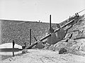
Pekina Creek dam around 1906
-
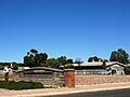
Town entrance
-
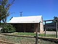
Settler's cottage
-
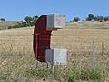
The big magnet
-
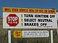
Sign at "Magnetic Hill"
.jpg)


