
Clare, South Australia facts for kids
Quick facts for kids ClareSouth Australia |
|||||||||||||||
|---|---|---|---|---|---|---|---|---|---|---|---|---|---|---|---|

Main North Road, looking north (Note the former town hall on the right side of main street)
|
|||||||||||||||

Clare
Location in South Australia
|
|||||||||||||||
| Established | 1842 | ||||||||||||||
| Postcode(s) | 5453 | ||||||||||||||
| Elevation | 392 m (1,286 ft) | ||||||||||||||
| Location | |||||||||||||||
| LGA(s) | District Council of Clare and Gilbert Valleys | ||||||||||||||
| Region | Yorke and Mid North | ||||||||||||||
| State electorate(s) | Frome | ||||||||||||||
| Federal Division(s) | Grey | ||||||||||||||
|
|||||||||||||||
The town of Clare is located in South Australia, about 136 kilometers north of Adelaide. It's famous for the Clare Valley wine and tourist area.
In 2016, Clare had a population of 3,160 people within its urban area.
Contents
History of Clare

The first European explorer to visit this area was John Hill in April 1839. He discovered and named the Wakefield River and Hutt River. Early in 1840, the first European settlers arrived, led by John Horrocks.
The town of Clare was officially started in 1842 by Edward Burton Gleeson. He named it after his family's home, County Clare in Ireland. At first, the town was called Inchiquin, which was the name of Gleeson's property. Today, a reservoir north of the town is called Lake Inchiquin.
The town's streets were designed in Adelaide, but it seems the person drawing the plans didn't know much about the local hills! Because of this, some roads in Clare suddenly stop at a cliff and then continue again at the top.
The local government for Clare, called the District Council of Clare, was set up in 1853. Later, a separate town council, the Corporation of Clare, was formed in 1868. These two councils joined back together in 1969 to manage the area.
A railway line was built to Clare from Riverton in 1918 and extended to Spalding in 1922. It closed in 1984 after being damaged by the Ash Wednesday fires in 1983. Now, the old railway path is a popular walking and cycling track called the Riesling Trail, which goes from Auburn to Barinia.
Clare Valley Wine History

Clare is where the Stanley Wine Company started in 1894. It was founded by Joseph Herman Knappstein. Today, the brand is owned by Accolade Wines and is known for its "drink now" cask wine. A local winery called "Mr. Mick" is named after Carl Knappstein, who was the managing director of Stanley Wine from 1962 to 1976. He was known as "Mick" and was a legendary winemaker.
Wine grapes have been grown around Clare since the early 1840s. The explorer John Horrocks planted the first grapevines at Penwortham. Edward Burton Gleeson, the founder of Clare, also planted about 800 vines at his Clare property, 'Inchiquin', in the 1840s. Many small vineyards were then planted by winemakers like J.H. Knappstein, John Hope, and John Christison.
For example, in 1904, the Stanley Wine Company sent a huge shipment of about 70,000 gallons of wine in casks to London. These Clare Valley wines were mostly Stanley port, known for its "unique and tasty flavor." This port, along with dry burgundy and brandy, was the main type of wine sold to Britain. To help them last the long journey, these wines were "fortified" with extra alcohol, similar to how Muscats and Port wines are made today.
One of Clare's most respected wineries is Wendouree, located south-east of Clare. It's a small, family-run winery that makes special organic wines. It was started in a small way in 1895 by Mr. A. P. Birks. Now, it's famous for its limited production of exclusive red wines. Even Penfold's famous Grange wine gets some of its grapes from the Clare Valley.
Clare Today: A Hub for Fun

Clare is one of the bigger towns in its region. It acts as a main center for services and administration for the surrounding area. It has:
- Two supermarkets
- Many other specialty stores
- Two public schools and two private schools
- Three hotels and two motels
- A caravan park
- A race course and showground
Clare is well-known for its outdoor activities and experiences. The Riesling Trail is a very popular walking and cycling path. It follows the old railway line for 25 kilometers, from 9 kilometers north of Clare to Auburn. It's named the Riesling Trail because it winds past many vineyards and wineries. This trail then continues to Riverton as the Rattler Trail.
The Riesling Trail is also a small part of the much longer Mawson Trail, which is about 900 kilometers long and stretches all the way up to the Flinders Ranges.
Clare is also the starting point of the Lavender Federation Trail. This trail goes along the eastern side of the Mount Lofty Ranges, past the Barossa Valley, and ends at Murray Bridge. The Clare Valley wine region is in the same line of hills as the famous Barossa Valley, and it also produces great wine.
The Clare Valley Wine and Wilderness Trail is a 100-kilometer path for hiking and cycling. It's designed to show off the amazing wines, food, and beautiful landscapes of the Clare Valley. It starts at the Clare Valley Information Centre, just south of Clare.
Things to See and Do in Clare
The town of Clare has several wineries right in town:
- The Knappstein Enterprise Winery, located at 2 Pioneer Ave, Clare SA (this used to be the old Clare Brewery).
- Mr. Mick Cellar Door and Restaurant, at 7 Dominic St, Clare SA (this used to be the old Stanley Winery).
There are also Jim Barry winery to the north and Tim Adams winery to the south. You can find about half a dozen restaurants in and around Clare, including those at the wineries.
Many more wineries surround the town, such as Taylors, Kirrihill, Kilikanoon, and Shut The Gate Wines. The Clare Valley actually has over forty places where you can taste wine!
- The Clarevale Cooperative Winery was another original winery in Clare, founded in 1930. Its buildings are still in Lennon Street.
- The Clare Valley Visitor Information Centre is part of the Clare Valley Wine, Food and Tourism Centre. You can find it 3 kilometers south of Clare on the Horrocks Highway.
.jpg)
- The Clare Museum, run by the National Trust of SA, is at the corner of Neagles Rock Road and Victoria Road, about 1 kilometer south of Main Street. It's open on Saturday afternoons and Sundays/public holidays.
- The Clare Regional History Group has a large collection of old books, newspapers, and items at the Clare Town Hall. You can visit on Friday afternoons and on monthly Saturday Market days.
- The Monthly Clare Show Market happens on the second Saturday of each month at Ennis Park, next to the Clare Town Hall.
- The Clare Valley Market is held in the car park at the Clare Valley Info. Centre on Spring Gully Rd. It's a special market held in March, September, and November.
- The Clare Mini-railway at "Lakeside Railway": The Clare Valley Model Engineers have a railway with over one kilometer of track. It has bridges and a tunnel in a 10-hectare park. The train runs every second and fourth weekend of each month at Melrose Park.
.jpg)
- The Gleeson Wetlands, which includes Lake Inchiquin, has an easy walking path. It's a great place to see many native birds in their natural home. There are picnic shelters and a bird hide. A path from here also connects to the Riesling Trail.
Amazing Lookouts Around Clare
There are five great lookouts near Clare where you can enjoy fantastic views:
- Billy Goat Hill, on Wright Street in central Clare, offers a great view of the town. You can walk up a high path above an old quarry or drive there via Union Street.
- Neagle's Rock Lookout is a favorite spot, just 1 kilometer south of the Clare Museum. It's a steep 20-minute walk to the top. This park has many important plants, including rare Peppermint Box trees. Listen for the songs of birds like the White-plumed Honeyeater, Australian Magpie, Adelaide Rosella, Grey Shrikethrush, and Rufous Whistler.
- Quarry Hill Lookout is a beautiful spot near Clare. You can find it on Quarry Road, about 4 kilometers south of Clare township. There's a display sign with information about the Clare Valley Rocks.

- Brooks Lookout, on the steep Old Blyth Road west of Armagh, gives you wide views west over Blyth township and the Condowie Plain. You might even catch a glimpse of Gulf St Vincent. This lookout is closed in summer due to bushfire danger.

- Spring Gully Conservation Park: This park, about 6 kilometers south of Clare, protects the only group of red stringybark trees (Eucalyptus macrorhyncha) in South Australia. It's also home to Peppermint Gum (Eucalyptus odorata), Southern Cypress Pine (Callitris gracilis), and Golden Wattle (Acacia pycnantha). It's a great place to see Blackboy Trees (Xanthorrhoea species) and possibly Western grey kangaroos and euros early in the morning or at dusk.
Art and History
- Clare Valley Art Gallery has a wide range of modern Indigenous art, with artists visiting regularly. It's at 28 Horrocks Highway, Clare.
- The Clare Art House offers exhibits, presentations, and art workshops at 8 Mill Street, Clare.
- The Riesling Trail passes by where the old Clare Railway Station used to be.
The Great Hill River Stone Wall

The amazing Hill River Stone Wall is thought to contain 7,040,000 stones! It starts about 3 kilometers south of the Farrell Flat road, east of Clare. It continues north over hills and valleys to Gum Creek, Leighton, Spalding, and Booborowie, finally ending at Canowie. It's believed that this wall was built in the 1860s by workers for the famous farmer C. B. Fisher, mainly to keep sheep from wandering off.
This wall is also known as "The Camel Hump Wall." It's a drystone wall (meaning no mortar was used) that runs for over 30 kilometers from Booborowie to Farrell Flat, and then another equal distance south, making it 62 kilometers long in total. It's said to be the longest continuous dry stone wall in Australia and should be protected as a heritage site.
Bungaree Station
Bungaree Station, located 12 kilometers north of Clare, is a historic property. It has a sandstone Woolshed (one of Australia's oldest working woolsheds, built starting in 1842), Shearers Quarters, a Stable Yard, a Station Store, the Manager's House, staff cottages, and even the old District Council Chambers and a Church. It's still a working farm, run by the 4th, 5th, and 6th generations of the Hawker family.
Bungaree was set up like a small English village, with a main house, a police station, and St Michaels Anglican Church (built in 1864). After wool prices dropped in 1985, Bungaree also started a successful tourism business.
- Bungaree Station in 1906
-
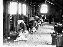
Shearing Sheep at Bungaree.
-
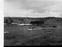
Bungaree Station buildings with sheep in 1906.
-
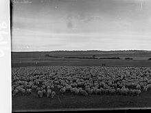
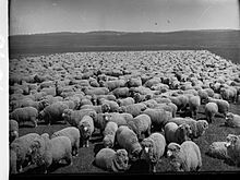
Bungaree with a mob of 1,960 sheep which had just walked to Bungaree from Paralana Station.
-
Bungaree Station with sheep in 1906. This closely resembles a photograph which hangs as an original framed print in the Bungaree woolshed.
.jpg)
.jpg)
.jpg)
.jpg)
.jpg)
.jpg)
These 1906 photos show a group of 1,960 sheep that had just walked to Bungaree from Paralana Station in the Northern Flinders Ranges (also run by the Hawker Family). One of these photos of Bungaree became famous because an engraving was made from it and used on both the £50 and £1000 Australian banknotes! (The £1000 note was used for transactions between banks).
The phrase "Australia was Riding on the Sheep's Back" means that for much of Australia's history, wool was the main product that helped the country's economy grow and was its biggest export. The farmers who grew the wool became symbols of what it meant to be Australian.
Other historic sheep stations in the Clare Valley include:
- Hill River Estate (east of Clare), started by C.B. Fisher.
- Hughes Park estate (south-west of Clare).
- Boconnoc Park estate, west of Armagh.
- The Kadlunga Estate, known for its good rainfall and for breeding Shropshire sheep. It's south-east of Clare, near Mintaro and its historic Martindale Hall.
Wineries in Clare Valley
Here is a list of some wineries in the Clare Valley, listed from north to south:
.jpg)

- Jim Barry Wines (Cellar Door)
- Mad Bastard Wines (Cellar Door)
- Knappstein Wines (Cellar Door)
- Mr Mick (Cellar Door, Restaurant)
- Sussex Squire Wines (Cellar Door)
- Tim Adams Wines (Cellar Door)
- Shut the Gate Wines (Cellar Door, Cafe)
- Stone Bridge Wines (Cellar Door)
- Eldredge Wines (Cellar Door)
- Jaeschke's Hill River Clare Estate (Cellar Door)
- Sevenhill Cellars (Cellar Door)
- Good Catholic Girl Wines (Cellar Door)
- Pikes Wines and Brewery (Cellar Door, Restaurant)
- The Wilson Vineyard (Cellar Door)
- Paulett Wines (Cellar Door, Restaurant)
- Jeanneret Wines & Clare Valley Brewing (Cellar Door)
- Skillogalee Wines & Restaurant (Cellar Door, Restaurant)
- Reilly's Wines and Restaurant (Cellar Door, Restaurant)
- Mitchell Wines (Cellar Door)
- Mintaro Wines (Cellar Door)
- Killikanoon Wines (Cellar Door)
- Penna Lane Wines (Cellar Door)
- Tim McNeil Wines (Cellar Door)
- Crabtree Watervale Wines (Cellar Door)
- clos Clare (Cellar Door)
- Claymore Wines (Cellar Door)
- Tim Gramp Wines (Cellar Door)
- O'Leary Walker Wines (Cellar Door, Restaurant)
- Taylors Wine (Cellar Door, Restaurant)
- Velvet and Willow Wines (Cellar Door)
- Wines by KT (Cellar Door)
- Grosset Wines (Cellar Door)
- Mount Horrocks Wines (Cellar Door)
- Ulster Park Wines (Cellar Door)
- Koonowla Wines/Georges (Cellar Door)

How Clare is Governed
Clare is managed by the local government body called the District Council of Clare and Gilbert Valleys. For state elections, Clare is in the Frome area, and for federal elections, it's in the Division of Grey area.
Geography and Climate of Clare
Clare is located in the Clare Valley, along the Hutt River. It's about 10 kilometers west of the Camels Hump Range and 3.5 kilometers west of Stony Range. To the south-west are the Skilly Hills, and to the north-west are the Bungaree Hills.
Clare's Weather
Clare has a hot-summer Mediterranean climate. This means it has hot, dry summers and cool, wetter winters. Temperatures change throughout the year. The average high temperature is about 30.4°C in January (summer) and 13.0°C in July (winter). The average low temperature is around 15.0°C in January and 4.1°C in July.
On average, Clare gets about 534.5 millimeters of rain each year, spread over about 117.7 rainy days. There are usually 102.7 clear days and 111.8 cloudy days every year. The hottest temperature ever recorded was 44.9°C on January 24, 2019, and the coldest was -5.0°C on June 15, 2006.
| Climate data for Clare (33º49'12"S, 138º35'24"E, 395 m AMSL) (1994-2024 normals, extremes 1957-2024) | |||||||||||||
|---|---|---|---|---|---|---|---|---|---|---|---|---|---|
| Month | Jan | Feb | Mar | Apr | May | Jun | Jul | Aug | Sep | Oct | Nov | Dec | Year |
| Record high °C (°F) | 44.9 (112.8) |
43.6 (110.5) |
40.4 (104.7) |
36.3 (97.3) |
28.7 (83.7) |
24.2 (75.6) |
25.0 (77.0) |
27.4 (81.3) |
32.2 (90.0) |
35.6 (96.1) |
41.1 (106.0) |
44.3 (111.7) |
44.9 (112.8) |
| Mean daily maximum °C (°F) | 30.4 (86.7) |
29.7 (85.5) |
26.3 (79.3) |
21.8 (71.2) |
17.1 (62.8) |
13.5 (56.3) |
13.0 (55.4) |
14.2 (57.6) |
17.5 (63.5) |
21.1 (70.0) |
24.9 (76.8) |
27.7 (81.9) |
21.4 (70.6) |
| Mean daily minimum °C (°F) | 15.0 (59.0) |
14.7 (58.5) |
12.3 (54.1) |
9.0 (48.2) |
6.4 (43.5) |
4.8 (40.6) |
4.1 (39.4) |
4.4 (39.9) |
6.1 (43.0) |
8.0 (46.4) |
10.7 (51.3) |
12.7 (54.9) |
9.0 (48.2) |
| Record low °C (°F) | 2.8 (37.0) |
4.9 (40.8) |
1.5 (34.7) |
−1.0 (30.2) |
−3.7 (25.3) |
−5.0 (23.0) |
−4.5 (23.9) |
−3.3 (26.1) |
−2.3 (27.9) |
−1.4 (29.5) |
0.0 (32.0) |
3.0 (37.4) |
−5.0 (23.0) |
| Average precipitation mm (inches) | 22.0 (0.87) |
23.3 (0.92) |
21.9 (0.86) |
36.7 (1.44) |
52.6 (2.07) |
66.2 (2.61) |
63.4 (2.50) |
66.3 (2.61) |
57.9 (2.28) |
46.3 (1.82) |
39.1 (1.54) |
37.3 (1.47) |
534.5 (21.04) |
| Average precipitation days (≥ 0.2 mm) | 4.7 | 4.1 | 5.4 | 7.4 | 11.6 | 15.0 | 17.0 | 16.3 | 12.2 | 9.1 | 8.1 | 6.8 | 117.7 |
| Average afternoon relative humidity (%) | 28 | 29 | 34 | 42 | 56 | 68 | 69 | 63 | 58 | 45 | 36 | 31 | 47 |
| Average dew point °C (°F) | 5.9 (42.6) |
6.5 (43.7) |
5.8 (42.4) |
5.7 (42.3) |
6.5 (43.7) |
6.3 (43.3) |
5.8 (42.4) |
5.5 (41.9) |
6.4 (43.5) |
5.0 (41.0) |
5.2 (41.4) |
4.9 (40.8) |
5.8 (42.4) |
| Source: Bureau of Meteorology (1994-2024 normals, extremes 1957-2024) | |||||||||||||
Famous People From Clare
Here are some notable people who are from or have lived in Clare:
- William Adey, an education expert
- Peter Albany Bell, a caterer and generous giver
- Hooper Brewster-Jones, a pianist and composer
- Luke Dunstan, an Australian rules football player
- Albert Fryar, a stamp collector and sportsman
- Edward Burton Gleeson, also known as "Paddy" Gleeson, who founded Clare (1803 -1870)
- George Charles Hawker, (1818–1895), an early settler and politician (1858–1895)
- Charles Hawker, a politician
- Riley Knight, an Australian rules football player
- H. H. Tilbrook, who helped start The Northern Argus newspaper and was a photographer
Images for kids
-

Old Kadlunga homestead near Mintaro, in 1901

