Spalding, South Australia facts for kids
Quick facts for kids SpaldingSouth Australia |
|
|---|---|

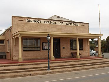
The former "District Council of Spalding" council chambers
|
|
| Established | 1885 (district council proclaimed) |
| Postcode(s) | 5454 |
| Elevation | 309 m (1,014 ft) |
| LGA(s) | Northern Areas Council |
| State electorate(s) | Stuart |
| Federal Division(s) | Grey |
Spalding is a small town in South Australia, located north of the Clare Valley. In 2016, about 215 people lived there.
It's mostly a farming community, and it also has a slate quarry where they dig up stone. Even though it's small, Spalding has important services like a supermarket, a hotel, a school, a post office, and a police station. It also has emergency services like the Country Fire Service (CFS) and the South Australian State Emergency Service (SES).
People think Spalding was named after a town called Spalding, Lincolnshire in the United Kingdom.
Spalding's Past
Before 1869, the land around Spalding was used for big sheep farms. But after that, the land became available for regular farmers, and a farming community started to grow.
In 1885, the area got its own local government, called the District Council of Spalding. This council helped run the town until 1997, when it joined with another council called the Northern Areas Council. A post office was built in Spalding in 1925.
Spalding used to have a railway line that connected it to Adelaide. Trains ran on this line from 1922 until 1978.
Two important historical places near Spalding are the Spalding Railway Bridge over the Broughton River and the old Bundaleer Reservoir site. Both of these are listed on the South Australian Heritage Register, which means they are protected because of their history.
Things to See and Do
- The Heysen Trail is a very long walking path, about 1200 kilometers (745 miles) in total. It passes right by Spalding, which is almost exactly in the middle of the trail!
 | Aurelia Browder |
 | Nannie Helen Burroughs |
 | Michelle Alexander |


