Exmouth Plateau facts for kids
Quick facts for kids Exmouth Plateau |
|
|---|---|

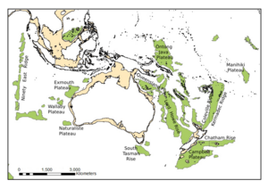
Oceanic plateaus around Australia and New Zealand
|
|
| Type | Extensional Passive Margin |
| Location | |
| Coordinates | 20°S 113°E / 20°S 113°E |
| Region | Northwestern Australia |
| Country | Australia |
The Exmouth Plateau is a large, long underwater landform. It stretches out into the Indian Ocean off the coast of Western Australia. Imagine a huge, flat-topped mountain hidden beneath the waves. This plateau is about 3,000 meters (almost 2 miles) below the ocean's surface.
It is the westernmost part of a bigger area called the Carnarvon Basin. This basin includes several smaller underwater areas. The Exmouth Plateau was once connected to the northern edge of a supercontinent called Gondwanaland. But, long, long ago, between 155 and 135 million years ago, it broke away. This separation created the deep ocean floors around it, known as the Argo, Cuvier, and Gascoyne abyssal plains.
Contents
Discovering the Exmouth Plateau
The Exmouth Plateau is a fascinating underwater region. It holds clues about how our continents moved and changed over millions of years. Scientists study its rocks and shape to understand Earth's ancient past.
How the Exmouth Plateau Formed
The story of the Exmouth Plateau is a tale of continents pulling apart. This process is called plate tectonics. It shaped the Earth's surface into what we see today.
The Breakup of Gondwana
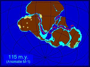
Around 155 million years ago, during the Late Jurassic period, the giant supercontinent Gondwanaland began to split. It broke into two main parts: Western Gondwana (South America and Africa) and Eastern Gondwana. Eastern Gondwana included Madagascar, India, Antarctica, and Australia.
At that time, Australia's southern edge was connected to Antarctica. Its western edge, where the Exmouth Plateau is now, was joined to Greater India. The northern edge of the Exmouth Plateau formed first. This happened about 155 million years ago when Australia separated from a piece of land that is now part of Asia.
About 20 million years later, Greater India pulled away from Western Australia. This created the central and southern edges of the Exmouth Plateau. These areas are now the Gascoyne and Cuvier Abyssal Plains. As Australia continued to move away from Antarctica, it slowly rotated and drifted northeast. This left the Exmouth Plateau along its western side.
Ancient Times: Triassic Period
During the Late Triassic period (about 237 to 201 million years ago), lots of sand and mud piled up. These sediments came from ancient rivers and deltas, like the Mungaroo Deltas, off Western Australia's coast. These deposits later formed coal in the Mungaroo Formation.
As India and Australia continued to pull apart, molten rock pushed up. This caused more stretching and breaking along the westernmost parts of the Exmouth Plateau. Towards the end of the Late Triassic, this activity slowed down. More marine sediments, like limestone (made from sea creatures), were laid down.
The Jurassic Journey: Continents Pull Apart
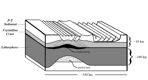
In the Early Jurassic period, the western Australian margin began to stretch. This stretching created many cracks, or faults, in the eastern Exmouth Plateau. These faults formed as the Earth's upper crust stretched and became thinner. At the same time, the deeper parts of the Earth's crust and lithosphere (the rigid outer layer) also stretched and thinned.
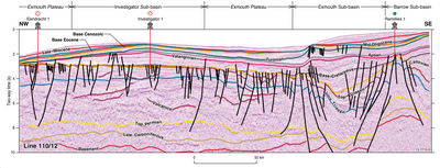
These cracks near the coast led to the first formation of the Exmouth, Barrow, and Dampier sub-basins. These are smaller sunken areas within the Northern Carnarvon Basin. During this time, limestone and marl (a mix of clay and limestone) were deposited in the central and western parts of the plateau. Closer to the shore, rivers and deltas deposited mud and silt.
The stretching continued into the Middle to Late Jurassic. More sunken areas and sideways-moving faults developed in the eastern Exmouth Plateau. The Earth's outer layer became much thinner. Molten rock also began to build up underneath this thin area.
The Cretaceous Period: New Oceans Emerge
By the Early Cretaceous period, the continents had completely broken apart. New ocean floor began to form. This marked the final shape of the Exmouth Plateau. After this, the plateau slowly sank over millions of years, from the Late Cretaceous until today. The major stretching and breaking activity in the eastern Exmouth Plateau had stopped. This completed the plateau's overall structure.
Layers of Rock: A Story in Stone
The rocks beneath the Exmouth Plateau tell a long story. They show how the environment changed from ancient rivers to deep oceans. These layers are called formations. They are like pages in Earth's history book.
The Locker Shale and Mungaroo Formation
The Locker Shale and Mungaroo Formation are very old rock layers. They formed during and after the continents started pulling apart. The Locker Shale is made of marine sediments. These were laid down when sea levels rose and covered the land. This happened during the Late Permian and Early Triassic periods.
The Mungaroo Formation came after the Locker Shale. It is a thick layer of sand, silt, and coal. These materials were deposited by ancient rivers and streams. This happened during the Middle to Late Triassic period. It is one of the thickest rock layers in the region, reaching about 3,000 meters (almost 2 miles) thick offshore. The Mungaroo Formation is important because it is a main source of natural gas for the Exmouth Plateau.
The Brigadier Formation
Above the Mungaroo Formation is a thinner layer called the Brigadier Formation. This layer consists of shallow marine claystone and limestone. It was deposited for a short time during the Late Triassic to Early Jurassic periods. Its presence shows that the land was slowly sinking during this time. This allowed the sea to cover it.
The Dingo Claystones
During the Jurassic period, the Northern Carnarvon Basin took its general shape. This created the Exmouth, Barrow, and Dampier sub-basins. As these areas sank quickly, thick layers of marine mud, called the Dingo Claystones, were deposited.
The lower parts of the Dingo Claystones mostly filled the deep troughs of these sub-basins. Later, during the Middle and Late Jurassic, as these troughs filled up, the Dingo Claystones spread further. The upper parts of the Dingo Claystones are found as thick layers in the sub-basins and thinner layers on the Exmouth Plateau.
The Barrow Group
Around 145 to 134 million years ago, during the Late Jurassic to Early Cretaceous, big changes happened. A large area called the Cape Range Fracture Zone lifted up. This caused a huge delta, the Barrow Delta, to spread sediments northward. These sediments, made of interbedded shale and river sands, formed the Barrow Group. They were deposited extensively into the Exmouth and Barrow sub-basins.
The Winning Group
Eventually, the Barrow Delta stopped depositing sediments. This happened around 134 million years ago. It was due to the final breakup of the continent at the southern edge of the Exmouth Plateau. New ocean floor then formed in the Gascoyne and Cuvier Abyssal Plains.
After this, a major rise in sea level occurred during the Middle to Late Cretaceous. This led to the deposition of the Winning Group. This group includes the Muderong Shale, Windalia Radiolarite, and Gearle Siltstone. The Muderong Shale is a marine siltstone. It formed in calm, offshore waters. It acts as a good seal, trapping natural gas in the Exmouth Plateau. The Windalia Radiolarite contains tiny sea creatures. The Gearle Siltstone also formed in calm, offshore waters, when little sediment came from the land.
 | Anna J. Cooper |
 | Mary McLeod Bethune |
 | Lillie Mae Bradford |


