
Fallen Timbers Battlefield facts for kids
|
Fallen Timbers Battlefield
|
|
.jpg)
A statue commemorating the battle
|
|

Location in Ohio

Location in the United States
|
|
| Location | Maumee, Ohio |
|---|---|
| Area | 9 acres (3.6 ha) (landmarked area) |
| Built | 1794 |
| Website | Fallen Timbers Battlefield and Fort Miamis National Historic Site |
| NRHP reference No. | 66000616 |
Quick facts for kids Significant dates |
|
| Added to NRHP | October 15, 1966 |
| Designated NHS | December 9, 1999 |
| Designated NHL | October 9, 1960 |
The Fallen Timbers Battlefield is a very important historical place in Maumee, Ohio. It's where the Battle of Fallen Timbers happened on August 20, 1794. This battle was a big win for the American army against Native American warriors and their British allies. It helped end the Northwest Indian War. This victory also made sure the Northwest Territory (a large area of land) was safe for American settlers to move into.
An area thought to be the battlefield was named a National Historic Landmark in 1960. This spot is now called the Fallen Timbers State Memorial. It's about 0.4 kilometers (0.25 miles) south of the real battlefield. The actual battlefield was found in 1995. Much of it is now protected as part of the Fallen Timbers Battlefield and Fort Miamis National Historic Site. This important site was created in 1999. It's managed by the National Park Service, Toledo MetroParks, and the Ohio Historical Society working together.
Contents
Exploring the Battlefield Site
The actual battlefield covers about 187 acres (76 hectares). It's located in southwestern Maumee. The area is mostly flat and open. However, there's a deep, wooded valley in the middle. This valley was a key part of the land that affected how the battle was fought.
For many years after the battle, the site remained mostly untouched. Some logging and farming happened there. But the deep valley was left alone because it was hard to get to. In 1995, archaeologists studied the area. They found the battlefield. Then, in 2001, more studies helped pinpoint where the battle lines were and other important spots.
Visiting the State Memorial
The state memorial is a different place from the national historic site. It's located south of the historic site, near the Maumee River. This memorial covers about 9 acres (3.6 hectares). It sits on high ground, giving visitors a great view of the river valley.
Commemorative Features
There are three main things to see at the memorial:
- The Battle of Fallen Timbers Monument: This large monument was put in place in 1929.
- A plaque: This plaque lists the names of the United States Army soldiers who fought in the battle.
- Turkey Foot Rock: This is a large rock with a turkey foot carved into it. People say it marks the spot where a brave Ottawa chief named Turkey Foot was killed.
The Mystery of Turkey Foot Rock
Turkey Foot Rock was moved from its original spot. It used to be about two miles south of Maumee City. From what we know now about the battle, its original location was not actually on the battlefield. Even though this memorial site was named a National Historic Landmark in 1960, new plans are being made. These plans will update the landmark's borders to include the real battlefield.
Images for kids
-
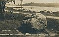
Turkey Foot Rock, at Fallen Timbers Battlefield
-
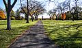
A path at Fallen Timbers Battlefield
-
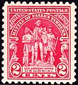
Stamp Commemorating the Battle of Fallen Timbers
-

Statue and memorial to Fallen Timbers Battlefield
-
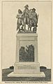
Historic postcard of the monument to General Anthony Wayne
.jpg)
.jpg)

.jpg)
.jpg)
