Farm Cove, New Zealand facts for kids
Quick facts for kids
Farm Cove
|
|
|---|---|
|
Suburb
|
|

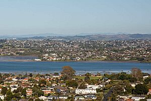
View of Farm Cove from Maungarei
|
|
| Country | New Zealand |
| Local authority | Auckland |
| Electoral ward | Howick ward |
| Local board | Howick Local Board |
| Area | |
| • Land | 84 ha (208 acre) |
| Population
(June 2023)
|
|
| • Total | 2,230 |
|
|
||
Farm Cove is a suburb located in East Auckland, New Zealand. It's part of the Howick area, which is one of Auckland's main divisions. A nice walking path called the Rotary Walkway Reserve goes through Farm Cove.
Contents
Exploring Farm Cove's Location
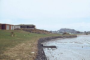
Farm Cove sits on the eastern side of the Tāmaki River. A small stream called Wakaaranga Creek creates the northern boundary. This stream separates Farm Cove from Half Moon Bay.
Near the shoreline at Sanctuary Point, you can find a cool fossil forest. These fossils are from ancient kauri trees. Scientists think these fossils formed after a volcanic eruption about 26,000 years ago.
A Glimpse into Farm Cove's Past
For its first 100 years, Farm Cove was mostly a rural area. It was considered part of Pakuranga. In 1843, a settler named Joseph Hargreaves bought land here. He built a house called Butley, close to where Farm Cove Intermediate is today.
More settlers arrived after 1847. This was when Howick was set up as a military outpost. Retired British soldiers and their families moved there. A ferry used to cross the Tāmaki River between 1847 and 1865. It carried people from Bramley Drive Reserve Beach to Point England. In the 1800s, the Gill dairy farm was also started in Farm Cove. It supplied milk to Auckland city.
How Farm Cove Grew
The suburb of Farm Cove was developed in the late 1960s and early 1970s. This was done by a company called Fletcher Construction. They named the suburb after Joseph Hargreaves' old farmhouse. Sadly, the original Butley house was taken down in 1972.
In 1971, the Pakuranga Junior Sailing Club moved to Farm Cove. Then, in 1973, the Farm Cove Shopping Centre opened. Later, in 1999, a private place for looking at stars, the Farm Cove Observatory, was built by Fred Goodfellow.
Who Lives in Farm Cove?
Farm Cove covers about 0.84 square kilometers. As of 2023, about 2,230 people live here. This means there are about 2655 people for every square kilometer.
The population has grown steadily over the years. In 2018, there were 2,583 people living in Farm Cove. About 19% of the people were under 15 years old. The median age was 43.1 years.
Different Backgrounds
Farm Cove is a diverse place. Many people have European backgrounds. There are also people from Māori, Pacific Island, and Asian backgrounds. About 37% of the people living here were born outside New Zealand.
When it comes to beliefs, many people in Farm Cove say they have no religion. Others identify as Christian, Hindu, Muslim, or Buddhist.
Many adults in Farm Cove have a university degree. The median income for people aged 15 and over was $39,400. Many people work full-time or part-time.
Learning in Farm Cove
Farm Cove has two main schools for younger students. They are both coeducational, meaning they have both boys and girls.
- Farm Cove Intermediate is for students in years 7 and 8. It opened in 1980.
- Wakaaranga School is a primary school for years 1 to 6. It opened in 1976. Its name means "The resting place of the canoe."
Both schools are located next to each other. There is also a small public kindergarten behind Wakaaranga Primary School.
 | Roy Wilkins |
 | John Lewis |
 | Linda Carol Brown |


