Farmer City, Illinois facts for kids
Quick facts for kids
Farmer City
|
|
|---|---|

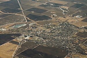
Aerial view of Farmer City
|
|

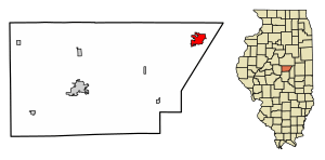
Location of Farmer City in De Witt County, Illinois.
|
|

Location of Illinois in the United States
|
|
| Country | United States |
| State | Illinois |
| County | DeWitt |
| Township | Santa Anna |
| Area | |
| • Total | 2.44 sq mi (6.33 km2) |
| • Land | 2.40 sq mi (6.20 km2) |
| • Water | 0.05 sq mi (0.12 km2) |
| Elevation | 715 ft (218 m) |
| Population
(2020)
|
|
| • Total | 1,828 |
| • Density | 763.26/sq mi (294.73/km2) |
| Time zone | UTC-6 (CST) |
| • Summer (DST) | UTC-5 (CDT) |
| ZIP Code(s) |
61842
|
| Area code(s) | 309 |
| FIPS code | 17-25414 |
| GNIS feature ID | 2394744 |
| Wikimedia Commons | Category:Farmer City, Illinois |
Farmer City is a small city in DeWitt County, Illinois, United States. In 2020, about 1,828 people lived there.
The city is part of the Blue Ridge Community Unit School District 18. It shares school buildings with nearby Mansfield and Bellflower, Illinois. Farmer City has the District Unit Office, Ruth M. Schneider Elementary School (for grades K-3), and Blue Ridge High School. In 2018, the city decided to become a Second Amendment sanctuary. This means they support the right to own guns.
Contents
History of Farmer City
Early Settlers and Native Americans
Long ago, Kickapoo and Potawatomi Native American tribes lived in this area. They lived near Salt Creek and other local streams. Around 1825, traders and adventurers began moving west. This led to the first settlers arriving.
Dennis Hurley is thought to be the first white settler. He built a cabin, and the area became known as Hurley's Grove. Other families, like the Kirbys and McCords, soon settled nearby. Hurley's Grove was just south of where Farmer City is today. By 1837, more people lived there. In 1839, it became part of DeWitt County.
Growth and Name Changes
The area south of Hurley's Grove became a lasting settlement. This was because the nearby woods offered safety. The northern part of the area was called Mt. Pleasant. The land was divided into 14 blocks, with a public square in the middle. Nathan Clearwater built the first home. William McFall opened a store in 1837.
Mail service started in 1837. But there was already another Mt. Pleasant in Illinois. So, the name was changed to Santa Anna.
Abraham Lincoln's Visits
In the early 1850s, DeWitt County was part of the Eighth Judicial District. A lawyer named Abraham Lincoln often traveled through the area for his work. He was well-liked by the people of the county. The C. H. Moore House in nearby Clinton was the home of one of Lincoln's fellow lawyers.
Becoming Farmer City
The settlement grew in size and population. The main part of town moved north. In 1870, a railroad connected the area, helping it to grow. That year, 1,276 people lived in the township, and 537 in Mt. Pleasant.
In 1869, the town needed an official name. After much discussion, Farmer City was chosen. A big fire destroyed the business district in 1879. But the town was rebuilt. Another fire in 1894 destroyed the new business district, so they had to rebuild again.
Modern Era Developments
In the early 1900s, Farmer City became a busy community. A newspaper, the Public Reaper, started printing in 1879. City leaders helped bring modern services, like a water tower in 1920. New schools, churches, and homes were built.
Interstate 74 was finished in the early 1970s. This highway helped connect Farmer City to other places. In 1980, a detailed study of how people speak in Farmer City was done. This made the city known in the field of language studies.
Geography
Farmer City covers about 2.449 square miles (6.34 km2) of land. Most of this area is land, with a small part being water.
Population Information
| Historical population | |||
|---|---|---|---|
| Census | Pop. | %± | |
| 1870 | 537 | — | |
| 1880 | 1,289 | 140.0% | |
| 1890 | 1,367 | 6.1% | |
| 1900 | 1,664 | 21.7% | |
| 1910 | 1,603 | −3.7% | |
| 1920 | 1,678 | 4.7% | |
| 1930 | 1,621 | −3.4% | |
| 1940 | 1,833 | 13.1% | |
| 1950 | 1,752 | −4.4% | |
| 1960 | 1,838 | 4.9% | |
| 1970 | 2,217 | 20.6% | |
| 1980 | 2,252 | 1.6% | |
| 1990 | 2,114 | −6.1% | |
| 2000 | 2,055 | −2.8% | |
| 2010 | 2,037 | −0.9% | |
| 2020 | 1,828 | −10.3% | |
| U.S. Decennial Census | |||
As of the 2020 census, 1,828 people lived in Farmer City. There were 848 households, which are groups of people living together. Most people living there were White (about 94%). A small number were African American, Native American, Asian, or from other backgrounds. About 2% of the population was Hispanic or Latino.
The average age in Farmer City was about 46.9 years old. About 24% of the people were under 18. Many households were married couples living together. The average income for a family was about $84,625. About 10.6% of the people lived below the poverty line.
Transportation
Major roads like Interstate 74 and State Route 54 meet near Farmer City. These roads are important for travel and trade. There are also railroad lines nearby, used by the Norfolk Southern Railway and Illinois Central Railroad.
Education
Farmer City is home to the Blue Ridge Community Unit School District 18. The sports teams from this district are known as the "Knights."
Media
Farmer City has its own FM radio station, WPEO-FM. It broadcasts on 98.3 mHz and plays Christian radio programs.
Notable People
Many interesting people have connections to Farmer City:
- Samuel B. Garver: An Illinois state representative, businessman, and farmer who lived in the city.
- Lott R. Herrick: An Illinois Supreme Court justice who was born in Farmer City.
- George Rock: An American singer famous for the song "All I Want for Christmas is My Two Front Teeth" with the Spike Jones Band.
- Vespasian Warner: A U.S. Representative from 1895 to 1905, also born in Farmer City.
See also
In Spanish: Farmer City para niños
 | Chris Smalls |
 | Fred Hampton |
 | Ralph Abernathy |


