
Farmland, Indiana facts for kids
Quick facts for kids
Farmland, Indiana
|
|
|---|---|
 |
|

Location of Farmland in Randolph County, Indiana.
|
|
| Country | United States |
| State | Indiana |
| County | Randolph |
| Township | Monroe |
| Area | |
| • Total | 0.53 sq mi (1.38 km2) |
| • Land | 0.53 sq mi (1.38 km2) |
| • Water | 0.00 sq mi (0.00 km2) |
| Elevation | 1,027 ft (313 m) |
| Population
(2020)
|
|
| • Total | 1,270 |
| • Density | 2,391.71/sq mi (923.60/km2) |
| Time zone | UTC-5 (EST) |
| • Summer (DST) | UTC-5 (EST) |
| ZIP code |
47340
|
| Area code(s) | 765 |
| FIPS code | 18-22792 |
| GNIS feature ID | 2396935 |
| Website | http://www.farmlandindiana.org |
Farmland is a small town located in Randolph County, Indiana, in the United States. It is part of Monroe Township. In 2010, about 1,333 people lived there.
Contents
Discovering Farmland's Past
Farmland is found in an area with rolling hills and interesting land features left behind by glaciers. The town was officially planned, or platted, in 1852. This happened when the railroad line was extended to reach this spot.
Why the Name "Farmland"?
The town likely got its name because of its very rich and fertile soil. This soil was perfect for farming. A post office opened in Farmland in 1853. The town officially became an incorporated town in 1867.
Historic Downtown and Famous Residents
The central part of Farmland, known as the Farmland Downtown Historic District, is a special place. It was added to the National Register of Historic Places in 1994. This means it's recognized for its important history.
If you visit Farmland, you might see a sign welcoming you. It mentions that the town is "The Home of Ansel Toney, The Kite Man." He was a well-known person from Farmland.
Exploring Farmland's Geography
Farmland is a small town in terms of its size. According to the 2010 census, the town covers a total area of about 0.53 square miles (1.37 km2). All of this area is land, with no large bodies of water.
Understanding Farmland's Population
The number of people living in Farmland has changed over many years. Here's a look at how the population has grown and shrunk:
| Historical population | |||
|---|---|---|---|
| Census | Pop. | %± | |
| 1870 | 532 | — | |
| 1880 | 661 | 24.2% | |
| 1890 | 770 | 16.5% | |
| 1900 | 870 | 13.0% | |
| 1910 | 907 | 4.3% | |
| 1920 | 878 | −3.2% | |
| 1930 | 853 | −2.8% | |
| 1940 | 914 | 7.2% | |
| 1950 | 943 | 3.2% | |
| 1960 | 1,102 | 16.9% | |
| 1970 | 1,262 | 14.5% | |
| 1980 | 1,560 | 23.6% | |
| 1990 | 1,412 | −9.5% | |
| 2000 | 1,456 | 3.1% | |
| 2010 | 1,333 | −8.4% | |
| 2020 | 1,270 | −4.7% | |
| U.S. Decennial Census | |||
Farmland's People in 2010
In 2010, a detailed count of the population was done. This count, called a census, showed that 1,333 people lived in Farmland. There were 543 households, which are groups of people living together. About 375 of these were families.
The town had about 2,515.1 inhabitants per square mile (971.1/km2) people per square mile. Most of the people living in Farmland were White (97.3%). A small number of residents were Native American or from other backgrounds. About 1.1% of the population identified as Hispanic or Latino.
Many households (32.6%) had children under 18 living there. More than half (52.5%) were married couples. The average household had 2.45 people. The average family had 2.94 people.
The average age of people in Farmland was 39.3 years old. About 24.4% of residents were under 18. About 15.8% were 65 years old or older. The town had slightly more females (52.0%) than males (48.0%).
Learning in Farmland
Farmland has a local library for its residents. It is called the Farmland Public Library. This library lends out books and other materials to the community.
Images for kids
-
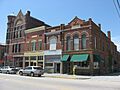
Farmland's downtown area

See also
 In Spanish: Farmland (Indiana) para niños
