
Flat Creek (Lake Lanier) facts for kids
Flat Creek is a small stream located in the state of Georgia, in the United States. It's like a smaller river that flows into a bigger one! Flat Creek is a tributary of the Chattahoochee River, which means it feeds into it. It eventually reaches Lake Lanier, a large and popular lake in Georgia. The creek is about 5.09 miles (8.19 kilometers) long.
Where Flat Creek Flows
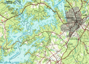
Flat Creek starts in the city of Gainesville, Georgia. This city is in Hall County. The very beginning of the creek, called its source, is just north of the Lee Gilmer Memorial Airport. It's also right next to State Route 60.
The creek first flows west. It quickly crosses two main roads, State Route 13 and State Route 53. After that, it gently curves southwest. It then runs alongside State Route 369 for a bit.
Just before reaching McEver Road, Flat Creek turns south. Then it turns west again to cross McEver Road. Finally, it flows into Lake Lanier. It enters the lake through a part called the Flat Creek arm. This part of the lake is separated from the main Chattahoochee River section by a piece of land. This land has State Route 369 running through it. You can reach it by crossing Browns Bridge from Forsyth County.
Understanding the Water Area
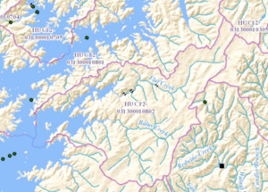
Every stream and river has a watershed. This is the entire area of land where all the rain and snowmelt drain into that specific stream or river. The Flat Creek watershed is a special area. The United States Geological Survey (USGS) has given it a specific code: HUC 031300010802. This code helps scientists track water systems.
This area is called the Flat Creek sub-watershed. It covers about 21 square miles (54 square kilometers). It's located southwest of Gainesville. Flat Creek drains the northern part of this area. This means all the water from rain and runoff in that northern section flows into Flat Creek.
The southern part of this watershed has another community called Oakwood. This southern area is drained by a different creek called Balus Creek. Balus Creek also flows into Lake Lanier, but it enters the lake south of where Flat Creek does. So, even though they are in the same general area, they have their own paths to the lake!
