Fort Billingsport facts for kids
Quick facts for kids Fort Billingsport |
|
|---|---|
| Billingsport, New Jersey | |

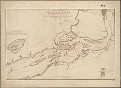
British map showing Billings Point or Billingport
|
|
| Lua error in Module:Location_map at line 420: attempt to index field 'wikibase' (a nil value). | |
| Type | Earthwork |
| Site history | |
| Built | 1776–1777 |
| Built by |
|
| Battles/wars | American Revolutionary War |
| Garrison information | |
| Past commanders |
William Bradford |
Fort Billingsport was an important fort during the American Revolutionary War. It was located in Billingsport, which is now part of Paulsboro. This fort was built on the Delaware River to help protect the new United States. Today, the site of the fort is a public park. It is called Fort Billingsport Park. The park is near the Port of Paulsboro.
Contents
Fort Billingsport's Story
Why Was the Fort Built?
The land for Fort Billingsport was bought on July 5, 1776. This was a very important purchase. It was the first land ever bought by the United States. The land was purchased by the Pennsylvania Committee of Safety. This group was authorized by the Continental Congress. The main reason for the fort was to protect the Delaware River. The river had underwater obstacles called chevaux de frise. These were like giant underwater spikes. They were placed to stop British ships from sailing up the river.
Building the Fort
A famous engineer named Tadeusz Kościuszko designed the fort. He was asked to do this by George Washington. Construction started under Robert Smith. He was also the designer of the river obstacles. Sadly, Robert Smith died in February 1777 while working on the fort.
Soldiers from New Jersey, Pennsylvania, South Carolina, and Virginia helped build the fort. They worked alongside other laborers and skilled workers. The original plan was for a very large fort. It was supposed to be about 700 feet across. It would have strong walls called a parapet, about 7.5 feet high.
However, there weren't enough materials or workers. So, the fort was built smaller than planned. It was a square-shaped earthwork (a fort made of earth). It had five cannons and a strong corner section called a redoubt. The fort also had barracks for soldiers, officers' quarters, and a bakehouse. But the fort was never fully finished.
The British Attack
The British army captured Philadelphia on September 26, 1777. This happened after they won the Battle of Brandywine. But the British still needed to get their ships up the Delaware River. Three lines of chevaux de frise blocked the river. Three forts also protected these obstacles. These forts were Fort Billingsport, Fort Mercer, and Fort Mifflin.
Fort Billingsport was near the second line of obstacles. On October 2, 1777, the British attacked Fort Billingsport. The fort's commander was William Bradford. He only had 112 men left. Many soldiers had left the fort. As the British got closer, Bradford's men quickly disabled their cannons. They also burned the barracks. Then, they left the fort.
The British took over Fort Billingsport. They tore down parts of the fort. They also cleared paths through the first two lines of chevaux de frise. They then moved upriver to attack Fort Mercer and Fort Mifflin. These forts guarded the last line of obstacles. The British tried to attack Fort Mercer in the Battle of Red Bank. But they were not successful. Fort Mifflin was attacked for a long time. It finally had to be abandoned on November 15, 1777. Fort Mercer was abandoned three days later.
After the Revolution
The British built a small fort with two cannons at the site of Fort Billingsport. But they left it when they moved out of Philadelphia on June 18, 1778. American soldiers, called Patriots, then took back the site. They rebuilt the fort and kept it manned until 1781. By then, the main fighting had moved to Yorktown, Virginia.
Fort Billingsport was used again during the War of 1812. About 1,300 militia soldiers camped there. In 1814, the fort was fixed up. It became a military training center. But by April 1825, the fort was described as "desolate." No buildings were left. In December 1834, the land was sold to Joseph C. Gill and John Ford for $2,000.
 | Janet Taylor Pickett |
 | Synthia Saint James |
 | Howardena Pindell |
 | Faith Ringgold |

