Fort Deposit, Alabama facts for kids
Quick facts for kids
Fort Deposit, Alabama
|
|
|---|---|

Fort Deposit, Alabama
|
|

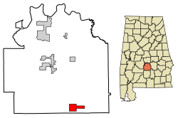
Location of Fort Deposit in Lowndes County, Alabama.
|
|
| Country | United States |
| State | Alabama |
| County | Lowndes |
| Area | |
| • Total | 5.66 sq mi (14.66 km2) |
| • Land | 5.66 sq mi (14.66 km2) |
| • Water | 0.00 sq mi (0.00 km2) |
| Elevation | 466 ft (142 m) |
| Population
(2020)
|
|
| • Total | 1,225 |
| • Density | 216.39/sq mi (83.54/km2) |
| Time zone | UTC-6 (Central (CST)) |
| • Summer (DST) | UTC-5 (CDT) |
| ZIP code |
36032
|
| Area code(s) | 334 |
| FIPS code | 01-27520 |
| GNIS feature ID | 0118518 |
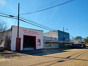
Fort Deposit is a small town in Lowndes County, Alabama, in the United States. It has been the largest town in Lowndes County since 1890. In 2020, about 1,225 people lived there. Fort Deposit is also part of the larger Montgomery area.
The town gets its name from a fort built by General Andrew Jackson. This fort was a supply base for soldiers during the Creek War. Every year, on the second weekend of April, the town hosts a fun arts and crafts fair called Calico Fort.
Fort Deposit became an official town on February 13, 1891. It is said to be on the highest point of land between Montgomery and New Orleans, Louisiana.
Contents
Where is Fort Deposit Located?
Fort Deposit is located at 31°59′16″N 86°34′16″W / 31.98778°N 86.57111°W. This means it's in a specific spot on the map.
The town covers a total area of about 14.6 square kilometers (5.6 square miles). All of this area is land, with no large bodies of water.
What is the Climate Like?
Fort Deposit has a humid subtropical climate. This means it usually has hot, humid summers and mild winters. There is rainfall throughout the year.
Who Lives in Fort Deposit?
The number of people living in Fort Deposit has changed over the years. Here's a quick look at the population from past records:
| Historical population | |||
|---|---|---|---|
| Census | Pop. | %± | |
| 1880 | 350 | — | |
| 1890 | 518 | 48.0% | |
| 1900 | 1,078 | 108.1% | |
| 1910 | 893 | −17.2% | |
| 1920 | 830 | −7.1% | |
| 1930 | 1,092 | 31.6% | |
| 1940 | 1,351 | 23.7% | |
| 1950 | 1,358 | 0.5% | |
| 1960 | 1,466 | 8.0% | |
| 1970 | 1,438 | −1.9% | |
| 1980 | 1,519 | 5.6% | |
| 1990 | 1,240 | −18.4% | |
| 2000 | 1,270 | 2.4% | |
| 2010 | 1,344 | 5.8% | |
| 2020 | 1,225 | −8.9% | |
| U.S. Decennial Census 2013 Estimate |
|||
Population in 2020
In 2020, the town had 1,225 residents. Most people in Fort Deposit are Black or African American. About 1 in 5 residents are White. A small number of people are of other races or mixed races.
Population in 2010
In 2010, there were 1,344 people living in Fort Deposit. These people lived in 512 households. About 348 of these households were families.
The town had 592 housing units. Most people in Fort Deposit were Black or African American (75.5%). About 23.7% were White. A small number of people were of mixed races or Hispanic/Latino.
About 29.5% of the people were under 18 years old. The average age in the town was 34.3 years.
Famous People from Fort Deposit
Some notable people have come from Fort Deposit:
- Ed Bell - A country blues singer and guitarist.
- Richard Williamson - A former head coach for the NFL team, the Tampa Bay Buccaneers.
Images for kids
-
Fort Deposit Post Office (ZIP code:36032)
See also
 In Spanish: Fort Deposit para niños
 | Stephanie Wilson |
 | Charles Bolden |
 | Ronald McNair |
 | Frederick D. Gregory |


