
Fort Drummond (Drummond Island, Michigan) facts for kids
|
Fort Drummond
|
|

Illustration of Fort Drummond
|
|

Location in Michigan

Location in the United States
|
|
| Location | W end of Drummond Island, Drummond Island, Michigan |
|---|---|
| Area | 84.5 acres (34.2 ha) |
| Built | 1815 |
| NRHP reference No. | 69000069 |
Quick facts for kids Significant dates |
|
| Added to NRHP | October 1, 1969 |
Fort Drummond, also known as Fort Colyer or Fort Collier, is an old military fort. It is located on the western side of Drummond Island in Michigan. This fort is special because it's the only known military and civilian site built by British forces on American land after the War of 1812. Fort Drummond was added to the National Register of Historic Places in 1969. It was also named a Michigan State Historic Site in 1956.
Contents
History of Fort Drummond
Why Was Fort Drummond Built?


The Treaty of Ghent was signed in late 1814. This treaty officially ended the War of 1812. It said that British troops had to leave Fort Mackinac on Mackinac Island. However, the news about the treaty didn't reach the soldiers at Fort Mackinac until May 15, 1815.
The British commander, Lieutenant Colonel Robert McDonall, was told to leave Fort Mackinac. He needed to set up a new military base within British territory. This new base had to be close to Mackinac Island. It was important for the British to stay near the Straits of Mackinac. This way, they could still have a strong influence over the Native American tribes. They also wanted to control the valuable fur trade in the upper Great Lakes area.
McDonall looked at several places nearby. He finally chose a spot on the west end of what is now Drummond Island. At that time, the island didn't even have a name. Moving all the supplies and soldiers to the new site took a long time. McDonall's troops didn't completely leave Fort Mackinac until July 18, 1815. After that, American forces took control of Fort Mackinac.
Building the Fort
Some of McDonall's soldiers were sent home in late 1815. But by the time they moved to Drummond Island, about 350 to 400 people were part of the fort. These men started building structures on Drummond Island. However, they weren't trained builders, so progress was slow.
There was also a problem: no one was sure if Drummond Island belonged to Britain or the United States. This was because of the Treaty of Ghent. So, the British were careful not to build a very strong fort. Eventually, they bought buildings from St. Joseph Island. These buildings belonged to the North West Company. They took them apart and rebuilt them on Drummond Island. This gave the soldiers shelter for the upcoming winter.
Because of the uncertainty about Drummond Island's ownership, the British government didn't spend much money or effort on fortifying Fort Drummond. Only a few military buildings were put up. There wasn't a clear line between the military and civilian parts of the "fort." Over the next few years, different officers took command. But the military setup on Drummond Island stayed mostly the same as it was in late 1815.
Leaving Fort Drummond
In 1822, it was finally decided that Drummond Island was actually part of the United States. This was confirmed by the Treaty of Ghent. Even so, the British forces were not quick to leave Fort Drummond. They stayed for several more years. During this time, they looked for a good new place to move their troops. They eventually chose a site in what is now Penetanguishene, in Ontario, Canada.
By 1828, the United States government demanded that the British leave Fort Drummond. The British quickly packed up. They shipped their soldiers and supplies to Penetanguishene. However, they didn't have enough shipping space. So, they left behind a lot of food and personal items like furniture.
American forces, led by Lieutenant T. Pierce Simonton, took over the fort on November 14, 1828. But the U.S. military did not actually live at the fort. Some of the houses in the village were still used for at least the rest of that winter. It's not clear exactly when the entire site was finally empty. At some point, a natural forest fire likely destroyed what was left of the fort.
What Fort Drummond Looked Like

The settlement at Fort Drummond had both military buildings and private homes. The main area was a "parade ground" facing the west side of the bay. A parade ground is an open space where soldiers gather for drills or ceremonies. The military barracks (where soldiers lived) and the commissary (where food and supplies were kept) were on the west side of this parade ground. The officers' living quarters were scattered around the area.
A long "boulevard" (a wide street) ran north from the parade ground for about 2,000 feet (610 meters). A military road also went south from the parade ground to the shore. The land east of the boulevard, between the boulevard and the bay, was used for gardens. Houses were built on the west side of the boulevard. The boulevard itself had rows of poplar trees on both sides.
Some of the houses were quite large, and a few had two stories. Other houses were simpler, made of poles covered with cedar bark. Kitchens for the houses were built a little distance away. Much of the cooking and baking was done in a public bakery that everyone could use.
The cemetery was located west of the fort, up on a ridge from the bay. It was a rectangular area, about 100 by 150 feet (30 by 46 meters), surrounded by a cedar rail fence. The cemetery probably holds around 300 people. Many of them died during a scurvy outbreak in the winter of 1815–1816. Others died from a smallpox outbreak in 1824. Many of the grave markers are now kept at the Drummond Island Museum.
South of the town, there was a lime quarry and a kiln. This was likely used to make mortar for the chimneys. A saw mill was also located north of the town. It's not certain if this mill was used at the same time as Fort Drummond. However, evidence of sawn logs was found in the fort buildings. Some small islands in Whitney Bay were also used by the fort. The fort's doctor lived on one island, and another was used for artillery practice.
Today, the Fort Drummond site is on private property. You can only see the site from the water. At least one of the old chimneys has been made part of a modern cabin. The Fort Drummond site has 74 features that can still be seen. Most of these are the remains of chimneys and building foundations. There are also two old wells, two wharves (docks), and the cemetery. You can still see faint traces of the old foundations.
Images for kids
-
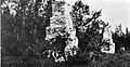
Remains of the barracks
-
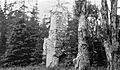
Remains of the officer's quarters
-
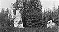
Remains of the officer's quarters
-
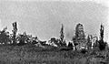
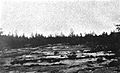
Ruins on the hill
-
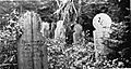
Headstones in the cemetery
-
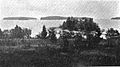
Harbor serving the fort
-
Looking out over the parade ground
-
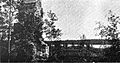
Looking out over the parade ground toward the harbor


