Fort McKay facts for kids
Quick facts for kids
Fort McKay
Fort MacKay
|
|
|---|---|

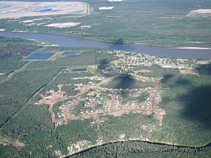
Aerial view of Fort McKay
|
|
| Country | Canada |
| Province | Alberta |
| Census division | No. 16 |
| Specialized municipality | RM of Wood Buffalo |
| Established | 1820 |
| Named | 1912 |
| Area | |
| • Total | 9.53 km2 (3.68 sq mi) |
| Elevation | 260 m (850 ft) |
| Population
(2016)
|
|
| • Total | 742 |
| • Density | 77.9/km2 (202/sq mi) |
| Time zone | UTC-7 (MST) |
| • Summer (DST) | UTC-6 (MDT) |
| Postal code span |
T0P
|
| Area code(s) | 780, 587, 825 |
| Highways | Highway 63 |
| Waterways | Athabasca River |
| Website | RM of Wood Buffalo |
Fort McKay (pronounced mə-KY) is a community in northeast Alberta, Canada. It sits where the Athabasca River and MacKay rivers meet. This community is about 54 kilometers (34 miles) north of Fort McMurray. You can reach it by taking Highway 63 and Fort McKay Road. The land here is about 260 meters (850 feet) above sea level.
Most of Fort McKay is an Indian settlement belonging to the Fort McKay First Nation (FMFN). A smaller part of the community, which was called Fort MacKay until 2018, is next to the FMFN lands. This smaller part is known as a hamlet within the Regional Municipality of Wood Buffalo.
Contents
Discovering Fort McKay's Past
The community received its name in 1912. It was named after Dr. Williams Morrison MacKay. He was the first president of the Northern Alberta Medical Association. The Fort McKay First Nation spells the community's name Fort McKay.
In 2012, the Fort McKay Métis Community asked the Regional Municipality of Wood Buffalo to change the hamlet's name to Fort McKay. This change became official on January 22, 2018.
The 2016 Wildfire Event
In 2016, a large wildfire affected the area. Fort McKay welcomed about 5,000 people who had to leave Fort McMurray. Later, Fort McKay itself was put on evacuation notice. This happened because the fire was moving north towards the community.
Fort McKay's Climate and Environment
Fort McKay has a subarctic climate. This means it has mild and short summers. The winters can be very long and cold. The area is in Plant Hardiness Zone 3a. This zone helps gardeners know which plants can survive the winter cold.
Understanding Fort McKay's Population
|
|||||||||||||||||||||||||||
The Fort McKay settlement has grown over the years. In the 2016 Census, 742 people lived there. They lived in 250 homes. This was a big increase from its 2011 population of 562 people.
The settlement covers an area of about 9.53 square kilometers (3.68 square miles). In 2016, there were about 77.9 people living per square kilometer.
Hamlet Population Details
The smaller hamlet part of Fort McKay also has its own population count. A census in 2018 showed that 59 people lived in the hamlet. This was an increase from 51 people counted in 2015.
Economy and Local Jobs
The main part of Fort McKay's economy is the Athabasca oil sands. These oil sands are located both south and north of the community. If you travel north on Highway 63, you will see many oil sands developments. These developments provide many jobs and support the local economy.
Transportation and Access
Fort McKay is located about 6 kilometers (3.7 miles) north of Highway 63. You can get there by taking Fort McKay Road. The community also has an airport nearby called the Fort MacKay/Horizon Airport. This airport helps people travel in and out of the area by air.


