Division No. 16, Alberta facts for kids
Quick facts for kids
Division No. 16
|
|
|---|---|
|
Census division in Alberta
|
|
| Country | Canada |
| Province | Alberta |
| Area | |
| • Total | 97,255 km2 (37,550 sq mi) |
| Population
(2021)
|
|
| • Total | 74,543 |
| • Density | 0.766470/km2 (1.985147/sq mi) |
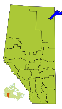
Division No. 16 is a special area in Alberta, Canada. It's called a census division because Statistics Canada uses it to count people. This area is in the northeast part of northern Alberta. It completely surrounds the big community of Fort McMurray.
Contents
What is Division No. 16?
Division No. 16 is like a large region that helps organize how people live in Alberta. It's not a city or a town itself. Instead, it includes different types of communities and lands within its borders.
Communities and Lands in Division No. 16
This area is made up of several different kinds of places. These are called census subdivisions. They include specialized municipalities, improvement districts, and lands set aside for Indigenous peoples.
Specialized Municipalities
A specialized municipality is a type of local government. It's set up to manage a large area that might have both urban and rural parts.
- The main one here is the Regional Municipality of Wood Buffalo. This is a very large area.
- Within this municipality, you'll find the Urban Service Area of Fort McMurray. This is the biggest community in Division No. 16.
Improvement Districts
An improvement district is an area that doesn't have its own local government. Instead, the provincial government manages it.
- One example in Division No. 16 is Improvement District No. 24. This is where the huge Wood Buffalo National Park is located.
Indigenous Lands
Division No. 16 also contains lands set aside for Indigenous communities. These are important places with their own unique histories and cultures.
- Indian reserves: These are lands managed by First Nations. Some examples in this division include Allison Bay 219, Fort McKay 174, and Gregoire Lake 176. There are many other reserves here too.
- Indian settlements: These are also communities for Indigenous peoples. One example is Fort Mackay.
How Many People Live Here?
We can look at how the population of Division No. 16 has changed over time. This helps us understand how the area has grown.
| Historical population | ||
|---|---|---|
| Year | Pop. | ±% |
| 1991 | 37,693 | — |
| 1996 | 36,494 | −3.2% |
| 2001 | 42,971 | +17.7% |
| 2006 | 53,080 | +23.5% |
| 2011 | 67,516 | +27.2% |
| 2016 | 73,988 | +9.6% |
| 2021 | 74,543 | +0.8% |
In 2021, Statistics Canada counted the people living in Division No. 16. The total population was 74,543. This was a small increase from 2016, when the population was 73,988.
The land area of Division No. 16 is about 94,072 square kilometers. This means that in 2021, there were about 0.8 people living in each square kilometer. This is called population density. It tells us how crowded an area is.
 | Lonnie Johnson |
 | Granville Woods |
 | Lewis Howard Latimer |
 | James West |


