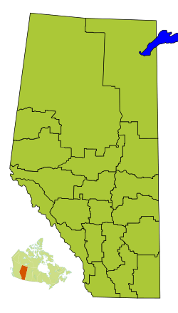
Division No. 18, Alberta facts for kids
Quick facts for kids
Division No. 18
|
|
|---|---|
|
Census division in Alberta
|
|
| Country | Canada |
| Province | Alberta |
| Area | |
| • Total | 33,205 km2 (12,821 sq mi) |
| As of 2011 | |
| Population
(2021)
|
|
| • Total | 13,226 |
| • Density | 0.398314/km2 (1.03163/sq mi) |
Division No. 18 is a special area in Alberta, Canada. It is known as a "census division." This means Statistics Canada uses it to count people and collect important information.
This division is found in the southeast part of northern Alberta. Its largest community is the Hamlet of Grande Cache. The edges of Division No. 18 match the edges of the Municipal District of Greenview No. 16.
Communities in Division No. 18
A "census subdivision" is like a local community or a group of communities. These are the different types of communities you can find inside Alberta's Division No. 18:
- Towns
- Hamlets
- Municipal districts
- Indian reserves
- Sturgeon Lake 154
- Sturgeon Lake 154A
How Many People Live Here?
| Historical population | ||
|---|---|---|
| Year | Pop. | ±% |
| 1991 | 13,979 | — |
| 1996 | 15,022 | +7.5% |
| 2001 | 14,346 | −4.5% |
| 2006 | 14,322 | −0.2% |
| 2011 | 14,534 | +1.5% |
| 2016 | 14,488 | −0.3% |
| 2021 | 13,226 | −8.7% |
In the 2021 Canadian census, Division No. 18 had a population of 13,226 people. These people lived in 4,999 homes. There are 6,219 total homes in the area.
The population changed a bit from 2016. In 2016, there were 14,488 people. This means the population went down by about 8.7% between 2016 and 2021.
The land area of Division No. 18 is 33,104.45 square kilometers. This means that in 2021, there were about 0.4 people living per square kilometer. This is called "population density."
 | Bayard Rustin |
 | Jeannette Carter |
 | Jeremiah A. Brown |


