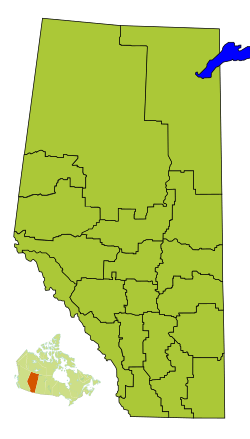
Division No. 19, Alberta facts for kids
Quick facts for kids
Division No. 19
|
|
|---|---|
|
Census division in Alberta
|
|
| Country | Canada |
| Province | Alberta |
| Area | |
| • Total | 20,454 km2 (7,897 sq mi) |
| Population
(2021)
|
|
| • Total | 121,167 |
| • Density | 5.92388/km2 (15.3428/sq mi) |
Division No. 19 is a special area in Alberta, Canada. It's like a big region used by the government to count people and gather information. This area is in the west-central part of northern Alberta. It completely surrounds the City of Grande Prairie.
Contents
Communities in Division No. 19
| Historical population | ||
|---|---|---|
| Year | Pop. | ±% |
| 1991 | 74,855 | — |
| 1996 | 79,665 | +6.4% |
| 2001 | 86,299 | +8.3% |
| 2006 | 98,712 | +14.4% |
| 2011 | 109,712 | +11.1% |
| 2016 | 120,380 | +9.7% |
| 2021 | 121,167 | +0.7% |
This section lists all the different types of communities found within Division No. 19. These are places where people live and work. They range from big cities to smaller villages and rural areas.
Cities
Towns
- Beaverlodge
- Fairview
- Falher
- Grimshaw
- McLennan
- Peace River
- Sexsmith
- Spirit River
- Wembley
Villages
Municipal Districts
- Birch Hills County
- Fairview No. 136, M.D. of
- Grande Prairie No. 1, County of
- Peace No. 135, M.D. of
- Saddle Hills County
- Smoky River No. 130, M.D. of
- Spirit River No. 133, M.D. of
Indian Reserves
- Duncan's 151A
- Horse Lakes 152B
Population Information
This section tells us about the people living in Division No. 19. In 2021, Statistics Canada counted the population. There were 121,167 people living here.
This number was a small increase from 2016. In 2016, the population was 120,380. Division No. 19 covers a large area of about 20,454 square kilometers (7,897 square miles).
 | Tommie Smith |
 | Simone Manuel |
 | Shani Davis |
 | Simone Biles |
 | Alice Coachman |


