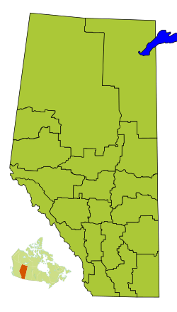
Division No. 13, Alberta facts for kids
Quick facts for kids
Division No. 13
|
|
|---|---|
|
Census division in Alberta
|
|
| Country | Canada |
| Province | Alberta |
| Area | |
| • Total | 24,374 km2 (9,411 sq mi) |
| Population
(2021)
|
|
| • Total | 68,076 |
| • Density | 2.79298/km2 (7.23377/sq mi) |
Division No. 13 is a special area in Alberta, Canada. It's called a census division. Most of this division is in the north-central part of Alberta. A smaller part is in northern Alberta. The biggest town in Division No. 13 is Whitecourt.
Contents
What is Division No. 13?
A census division is like a large region that Statistics Canada uses to count people. It helps them organize information about where people live. Division No. 13 covers a big area of land. It has many different types of communities within its borders.
Communities and Areas
Inside Division No. 13, you'll find different kinds of communities. These are called census subdivisions. They include towns, villages, and even special areas for Indigenous communities.
Towns and Villages
The biggest communities in Division No. 13 are its towns. These are places where many people live and work. Some of the towns you can find here are Athabasca, Barrhead, and Whitecourt. There are also smaller communities called villages, like Alberta Beach and Boyle.
Rural Areas
Much of Division No. 13 is made up of rural areas. These are often managed by what are called municipal districts. Examples include Athabasca County and Lac Ste. Anne County. These areas often have farms, forests, and open spaces.
Indigenous Communities
Division No. 13 also includes Indian reserves. These are lands set aside for First Nations people. An example is Alexis 133. These communities are important parts of the division's history and culture.
People and Population
The number of people living in an area is called its population. This information helps us understand how communities are growing or changing.
How Many People Live Here?
In 2021, about 68,076 people lived in Division No. 13. This number changes over time. For example, in 2016, there were more people living here. The area of Division No. 13 is about 24,308 square kilometers. This means we can figure out how many people live in each square kilometer.
| Historical population | ||
|---|---|---|
| Year | Pop. | ±% |
| 1991 | 58,102 | — |
| 1996 | 62,569 | +7.7% |
| 2001 | 63,954 | +2.2% |
| 2006 | 66,972 | +4.7% |
| 2011 | 68,919 | +2.9% |
| 2016 | 71,016 | +3.0% |
| 2021 | 68,076 | −4.1% |
The population has changed over the years. In 1991, about 58,102 people lived here. The population grew steadily until 2016. Then, it saw a small decrease by 2021.
 | Jessica Watkins |
 | Robert Henry Lawrence Jr. |
 | Mae Jemison |
 | Sian Proctor |
 | Guion Bluford |


