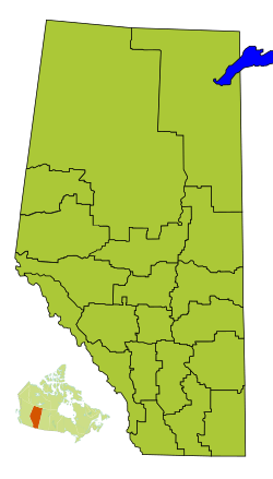
Division No. 1, Alberta facts for kids
Quick facts for kids
Division No. 1
|
|
|---|---|
|
Census division in Alberta
|
|
| Country | Canada |
| Province | Alberta |
| Area | |
| • Total | 20,526 km2 (7,925 sq mi) |
| Population
(2021)
|
|
| • Total | 82,513 |
| • Density | 4.01993/km2 (10.4116/sq mi) |
Division No. 1 is a special area in Alberta, Canada. It's called a census division, which means it's a region used by the government to count people and gather information. This division is found in the very southeast part of southern Alberta. It completely surrounds the big city of Medicine Hat.
Division No. 1 is made up of two main areas called municipal districts: Cypress County and Forty Mile No. 8.
Towns and Communities in Division No. 1
This part of Alberta includes several different types of communities. These are called census subdivisions. They can be cities, towns, villages, or even smaller places called hamlets.
- Cities
- Medicine Hat is the largest city in this division.
- Towns
- Villages
- Hamlets
- Municipal Districts
How Many People Live Here?
| Historical population | ||
|---|---|---|
| Year | Pop. | ±% |
| 1991 | 58,197 | — |
| 1996 | 62,330 | +7.1% |
| 2001 | 67,402 | +8.1% |
| 2006 | 74,550 | +10.6% |
| 2011 | 78,694 | +5.6% |
| 2016 | 82,627 | +5.0% |
| 2021 | 82,513 | −0.1% |
Every few years, Statistics Canada (which is Canada's national statistics office) counts all the people living in the country. This is called a census.
In the 2021 Census, Division No. 1 had a total population of 82,513 people. These people lived in 33,807 homes. This number was a very small change from the 2016 census, where 82,627 people lived here.
The total land area of Division No. 1 is about 20,277.52 square kilometers (which is about 7,829.19 square miles). This means that in 2021, there were about 4.1 people living in each square kilometer of land.
See also
 In Spanish: División n.º 1 (Alberta) para niños
 | Roy Wilkins |
 | John Lewis |
 | Linda Carol Brown |


